ArcGIS Desktop

  • ArcGIS Pro
  • ArcMap

  • My Profile
  • ヘルプ
  • Sign Out
ArcGIS Desktop

ArcGIS Online

組織のマッピング プラットフォーム

ArcGIS Desktop

完全なプロ仕様の GIS

ArcGIS Enterprise

エンタープライズ GIS

ArcGIS Developers

位置情報利用アプリの開発ツール

ArcGIS Solutions

各種業界向けの無料のテンプレート マップおよびテンプレート アプリケーション

ArcGIS Marketplace

組織で使えるアプリとデータを取得

  • ドキュメント
  • サポート
Esri
  • サイン イン
user
  • マイ プロフィール
  • サイン アウト

ArcMap

  • ホーム
  • はじめに
  • マップ
  • 解析
  • データ管理
  • ツール
  • エクステンション

Choosing centerlines for editing activities

When constructing or modifying route features, it is important to ensure that the updated alignment is correct and accurate. ArcGIS provides a number of tools for editing line geometry. ArcGIS Roads and Highways provides tools for incorporating the updated line work into the linear referencing system (LRS).

Edits to geometry can also be made outside of ArcGIS as shapefiles, and computer-aided design and drafting (CADD) files are supported in addition to ArcGIS feature classes. Centerline features must be polyline features.

Centerlines are selected using the Choose Centerlines tool on the Roads And Highways Editing toolbar.
メモ:
  • Centerline features do not need to be M- or Z-enabled to work with Roads and Highways.
  • If your centerline is a multipart feature, you can use ArcGIS Desktop geoprocessing tools to convert the multipart line to singlepart. For more information, see Multipart To Singlepart. You may prefer to use a singlepart feature if you want to flip the direction of the centerline or reorder each individual part.
  1. Start ArcMap and add an LRS Network and redline feature class to your map.
  2. Add the feature or feature layers you want to use for your centerlines.
  3. Start an edit session.
  4. On the Roads And Highways Editing toolbar, select a target LRS Network.
  5. Click the Choose Centerlines button Choose Centerlines on the Roads And Highways Editing toolbar.

    メモ:

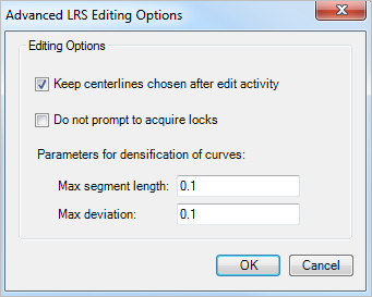
    If your centerline was created as a curve, Roads and Highways will convert the curve into a densified polyline feature. To set the level of densification of curves to polylines, click the Advanced LRS Editing Options button on the Roads And Highways Editing toolbar.

    Advanced LRS Editing Options

  6. Choose one or more centerlines by pressing and holding the Shift key.

    You can choose multiple centerlines for the create, extend, and realign route activities.

    Pressing the Shift key allows you to define the order of the centerlines. The order in which the centerlines are selected determines the increasing direction of measure calibration. The direction of digitization of the centerline, depicted by the direction of the arrowhead on the selected centerline, also determines the direction of increasing measure calibration. To change the direction of calibration on a centerline, use the Flip Geometry command by right-clicking the selected centerline. This is helpful if you want to flip the current direction, for example, in a roundabout.

    In this example, multiple centerlines are selected with their order and direction of calibration defined.
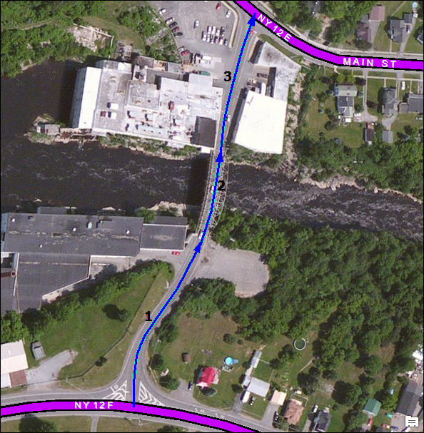
    Selecting multiple centerlines
    メモ:

    You can keep the centerlines chosen after the edit activity. To do so, click the Advanced LRS Editing Options button on the Roads And Highways Editing toolbar and check the Keep centerlines chosen after edit activity option.

    Advanced LRS Editing Options

ArcGIS Desktop

  • ホーム
  • ドキュメント
  • サポート

ArcGIS

  • ArcGIS Online
  • ArcGIS Desktop
  • ArcGIS Enterprise
  • ArcGIS
  • ArcGIS Developer
  • ArcGIS Solutions
  • ArcGIS Marketplace

Esri について

  • 会社概要
  • 採用情報
  • Esri ブログ
  • ユーザ カンファレンス
  • デベロッパ サミット
Esri
ご意見・ご感想をお寄せください。
Copyright © 2021 Esri. | プライバシー | リーガル