Production Mapping ライセンスで利用できます。
概要
Fills gaps between polygon features that participate in a topology where the coincident boundaries are evident.
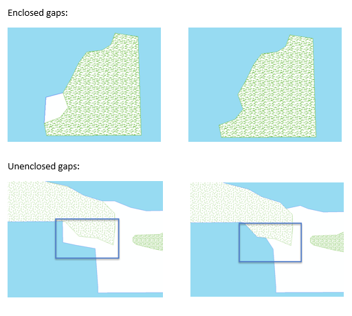
Many types of polygon features should have coincident boundaries with other features. Coincident boundaries can be important for features in a single polygon feature class, such as parcels, or between features in different feature classes, such as lakes and surrounding vegetation. A gap between the features exists when there is space between the boundaries of two or more features.
図

使用法
If this tool is run in an edit session in ArcMap, you can stop the edit session without saving changes to restore features that have been modified.
This tool requires one or more input feature classes. If only one input feature class is specified, the tool will search for gaps between individual features in that feature class. When multiple feature classes are specified, the tool will search for gaps between all features in all the input feature classes. The tool will find gaps between two features in the same feature class as well as gaps between features in different feature classes.
When multiple compare feature layers are provided and the Fill Options parameter is set to Fill By Length, the area of the gap is added to the feature class that shares the longest boundary with the gap. For instance, if a gap shares a longer boundary with vegetation features and a shorter boundary with lake features, the area of the gap will be added to the feature in the vegetation layer.
The order of the inputs in the Input Polygon Features parameter list is important when the Fill Options parameter is set to Fill By Order. For instance, if vegetation is first in the list, and lakes are the second input polygons when Fill By Order is chosen, the vegetation features will always be adjusted to fill the gap.
When searching for gaps between features in multiple feature classes, add all of the feature classes as input polygons. For example, if there should be no gaps between features in the lakes, grass, and forest feature classes, add them to the Input Polygon Features parameter. If you add only lakes and forests, the tool will identify a gap between lakes and forests and fill the gap. However, the area that was identified as a gap may have had a grass feature, which results in the modified feature overlapping the grass. To prevent overlaps, add all relevant feature classes to the Input Polygon Features parameter.
Unenclosed gaps exist when two polygon boundaries are within a specified distance of each other. The two polygon features do not have to touch each other at any point.
When the Fill Unenclosed Gaps parameter is checked, the unenclosed gaps will be filled first. Enclosed gaps will be filled after unenclosed gaps are filled.
Enclosed gaps exist when there are gaps between two polygon boundaries.
This tool fills holes in a single feature but does not fill unenclosed gaps between the edges of a single feature. If a feature is a multipart feature, the gaps between the parts will not be filled. If a feature curves and different parts of the edge are close to each other and create small gaps, the gaps along the edge will not be filled.
構文
arcpy.production.FillGaps(in_polygon_features, maximum_gap_area, fill_options, {fill_unenclosed_gaps}, {maximum_gap_distance})| パラメーター | 説明 | データ タイプ |
in_polygon_features [in_polygon_features,...] | A list of input polygon feature classes or layers to be analyzed for gaps. | Feature Layer |
maximum_gap_area | The maximum area that can be considered a gap. Areas larger than this threshold will not be filled. | Areal unit |
fill_options | Specifies how enclosed and unenclosed gaps will be filled.
| String |
fill_unenclosed_gaps (オプション) | Specifies whether the tool will fill unenclosed gaps.
| Boolean |
maximum_gap_distance (オプション) |
The maximum distance between features in which a gap can be filled. This parameter is used only when the fill_unenclosed_gaps parameter is set to FILL_ALL. | Linear Unit |
コードのサンプル
FillGaps example 1 (stand-alone script)
The following stand-alone script demonstrates how to use the FillGaps function to eliminate the spaces between enclosed polygon features.
# Name: FillGapsExample_1.py
# Description: Fills gaps between features
# Author: Esri
# Date: March 2015

# Import arcpy module
import arcpy

# Import toolbox
arcpy.ImportToolbox(r'C:\Program Files (x86)\ArcGIS\EsriProductionMapping\Desktop10.3\ArcToolbox\Toolboxes\Production Mapping Tools.tbx')

# Check out Production Mapping license
arcpy.CheckOutExtension("Foundation")

# Set environment
worksp = "C:\data\FillGaps.gdb"

# Define variables
inPoly1 = "C:\data\FillGaps.gdb\BuiltupA"
inPoly2 = "C:\data\FillGaps.gdb\LakeresA"
inPoly3 = "C:\data\FillGaps.gdb\PolbndA"
max_gap = "700000 SquareMeters"
fill_options = "FILL_BY_LENGTH"
fill_unenclosed_gaps = "FILL_ENCLOSED_ONLY"

# Create feature layer for input features
arcpy.MakeFeatureLayer_management(inPoly1,"inBuiltupLyr")
arcpy.MakeFeatureLayer_management(inPoly2,"inLakeResLyr")
arcpy.MakeFeatureLayer_management(inPoly3,"inPolbndLyr")

# Fill gaps between the different layers
arcpy.FillGaps_production("inBuiltupLyr;inLakeResLyr;inPolbndLyr",max_gap, fill_options, fill_unenclosed_gaps)

# Check in Production Mapping license
arcpy.CheckInExtension("Foundation")
FillGaps example 2 (stand-alone script)
The following stand-alone script demonstrates how to use the FillGaps function to eliminate the spaces between unenclosed polygon features.
# Name: FillGapsExample_2.py
# Description: Fills gaps between features
# Author: Esri
# Date: March 2015

# Import arcpy module
import arcpy

# Import toolbox
arcpy.ImportToolbox(r'C:\Program Files (x86)\ArcGIS\EsriProductionMapping\Desktop10.3\ArcToolbox\Toolboxes\Production Mapping Tools.tbx')

# Check out Production Mapping license
arcpy.CheckOutExtension("Foundation")

# Set environment
worksp = "C:\data\FillGaps.gdb"

# Define variables
inPoly1 = "C:\data\FillGaps.gdb\BuiltupA"
inPoly2 = "C:\data\FillGaps.gdb\LakeresA"
inPoly3 = "C:\data\FillGaps.gdb\PolbndA"
max_gap = "700000 SquareMeters"
fill_options = "FILL_BY_LENGTH"
fill_unenclosed_gaps = "FILL_ALL"
max_gap_distance = "20 Meters"

# Create feature layer for input features
arcpy.MakeFeatureLayer_management(inPoly1,"inBuiltupLyr")
arcpy.MakeFeatureLayer_management(inPoly2,"inLakeResLyr")
arcpy.MakeFeatureLayer_management(inPoly3,"inPolbndLyr")

# Fill gaps between the different layers
arcpy.FillGaps_production("inBuiltupLyr;inLakeResLyr;inPolbndLyr",max_gap, fill_options, fill_unenclosed_gaps, max_gap_distance)

# Check in Production Mapping license
arcpy.CheckInExtension("Foundation")
環境
ライセンス情報
- Basic: いいえ
- Standard: 次のものが必要 Production Mapping
- Advanced: 次のものが必要 Production Mapping