Production Mapping ライセンスで利用できます。
概要
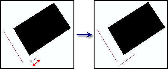
Increases the lengths of lines from the center until they meet a specified length.
図

使用法
A warning is raised if the input features are not in a projected coordinate system. This tool relies on linear distance units, which will create unexpected results in an unprojected coordinate system. It is strongly suggested that you run this tool on data in a projected coordinate system to ensure valid results. An error is raised and the tool will not process if the coordinate system is missing or unknown.
The lines are extended from both sides of the center point.
If this tool is run in an edit session in ArcMap, you can stop the edit session without saving changes to restore features that have been deleted.
構文
arcpy.production.IncreaseLineLength(Input_Line_Features, Minimum_Length)
| パラメーター | 説明 | データ タイプ |
Input_Line_Features | The line features to be lengthened. | Feature Layer |
Minimum_Length | Any feature shorter than this length will be extended in both directions until it meets the minimum length value. | Linear unit |
コードのサンプル
IncreaseLineLength example (stand-alone script)
The following stand-alone sample script demonstrates how to use Increase Line Length.
# Name: IncreaseLineLength_Example.py
# Description:
# Author: Esri
# Date: February 2014

# Import arcpy module
import arcpy

# Check out Production Mapping license
arcpy.CheckOutExtension("Foundation")

# set environment
arcpy.env.workspace="c:/data/LocalGovernment.gdb"

# Define variables
inFeatures="ReferenceData/RoadCenterline"
inFeatureLyr="RoadLayer"
minLength="400 feet"

# make a feature layer from road centerlines
arcpy.MakeFeatureLayer_management(inFeatures,inFeatureLyr)

# Execute ExtendPolygonSides
arcpy.IncreaseLineLength_production(inFeatureLyr,minLength)
環境
ライセンス情報
- Basic: いいえ
- Standard: 次のものが必要 Production Mapping
- Advanced: 次のものが必要 Production Mapping