Production Mapping ライセンスで利用できます。
概要
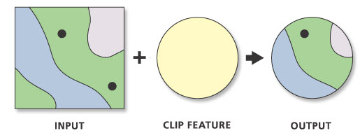
This tool takes a geodatabase and clip geometry, as well as any clip override representations, present on the features.
図

使用法
Everything will be clipped in the geodatabase that can be clipped. To get the best results, copy only the necessary data to another database before running the tool.
Clip Features must be polygons.
This tool works directly on the Input Geodatabase.
構文
arcpy.production.ProductionClip(input_geodatabase, clip_features)
| パラメーター | 説明 | データ タイプ |
input_geodatabase | The geodatabase that contains the features to be clipped. | Workspace |
clip_features | The features used to clip the Input Geodatabase. | Feature Layer |
コードのサンプル
The following stand-alone sample script demonstrates how to use ProductionClip tool.
# Name: ProductionClip_Example.py
# Description: Clips the underlying geometry as well as override geometry if applicable.  The tool clips an entire geodatabase.

# Import system modules
import arcpy

# Check out extension
arcpy.CheckOutExtension("Foundation")

# Define variables
input_geodatabase = r"C:\data\Edit_Sample.gdb"
clip_features = arcpy.MakeFeatureLayer_management(r"C:\data\Edit_Sample.gdb\10k_AOIs", "AOIs")
arcpy.SelectLayerByAttribute_management("AOIs", "NEW_SELECTION", "SheetID = 2104")

# Execute Production Clip
# All feature classes will be clipped in the geodatabase using the selected clip features
arcpy.ProductionClip_production(input_geodatabase, clip_features)

# Check in Production Mapping license
arcpy.CheckInExtension("Foundation")
環境
ライセンス情報
- Basic: いいえ
- Standard: 次のものが必要 Production Mapping
- Advanced: 次のものが必要 Production Mapping