ArcGIS Desktop

  • ArcGIS Pro
  • ArcMap

  • My Profile
  • Справка
  • Sign Out
ArcGIS Desktop

ArcGIS Online

Картографическая платформа вашей организации

ArcGIS Desktop

Полноценная профессиональная ГИС

ArcGIS Enterprise

ГИС предприятия

ArcGIS for Developers

Инструменты для встраивания приложений с местоположениями

ArcGIS Solutions

Бесплатные шаблоны карт и приложений для отрасли

ArcGIS Marketplace

Получение приложения и данных для вашей организации.

  • Документация
  • Поддержка
Esri
  • Войти
user
  • Мой профиль
  • Выход

ArcMap

  • На главную
  • Начало работы
  • Карта
  • Анализ
  • Управление данными
  • Инструменты
  • Дополнительные модули

Adding a WFS connection

Доступно с лицензией Production Mapping.

The Open Geospatial Consortium (OGC) Web Feature Service (WFS) provides a way to make your maps and data available in an easily accessible and recognized format over the web. The WFS specification is an open specification for serving geographic features to anyone with a supported client application. You can publish a WFS service to ArcGIS Server by enabling the WFS capability when you publish a map or image service in ArcGIS Desktop.

To configure your WFS connection, follow these steps:

  1. Запустите ArcMap.
  2. Open the Catalog window.
  3. Under GIS Servers, double-click Add WFS Server.
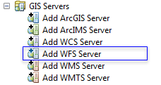
    Add WFS Server

    The Add WFS Server dialog box appears.

  4. Type the service URL.
  5. If applicable, enable service authentication and provide the username and password.
  6. If applicable, browse to a workspace schema XML that matches the data on the service.

    This allows the usage of domains and subtypes if the workspace XML uses them. This is optional.

  7. Click Get Layers to preview what the service contains.
  8. Нажмите ОК.

ArcGIS Desktop

  • На главную
  • Документация
  • Поддержка

ArcGIS Platform

  • ArcGIS Online
  • ArcGIS Desktop
  • ArcGIS Enterprise
  • ArcGIS for Developers
  • ArcGIS Solutions
  • ArcGIS Marketplace

Об Esri

  • О нас
  • Карьера
  • Блог Esri
  • Конференция пользователей
  • Саммит разработчиков
Esri
Расскажите нам, что вы думаете.
Copyright © 2019 Esri. | Конфиденциальность | Правовая информация