Доступно с лицензией Production Mapping.
Data sources can be associated with several components in several Esri Mapping and Charting solutions. In addition to feature layers, data sources can be defined for Reviewer checks and map series. All of these need a geodatabase that can be referenced as a data source, which can be a feature class in a personal, file, or enterprise geodatabase.
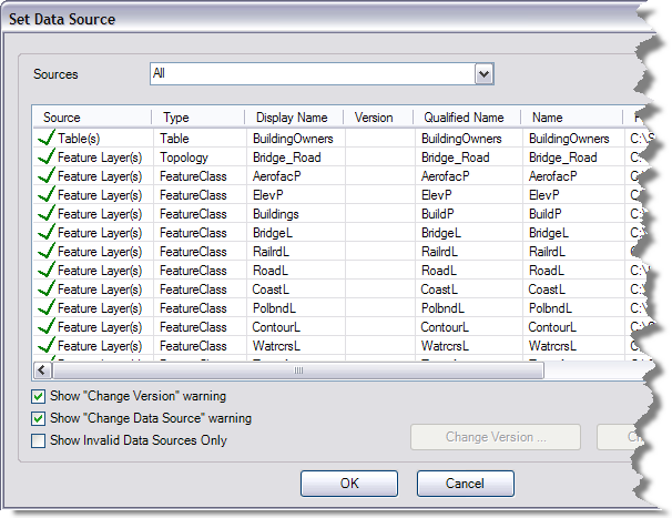
Properties for each item include the following:
- Type—The type of item that is using the data source reference
- Display Name—The name of the feature class being referenced as it is displayed in the table of contents or the Reviewer check
- Version—The database version being referenced
- Name—The name of the feature class being referenced, which includes the full path if you are using an enterprise geodatabase
- Unqualified Name—The name of the feature class
- Workspace Path—The full path to the current workspace being referenced
With enterprise geodatabases, the paths to the data source include the version as well as the geodatabase. You can opt to change only the version for the data source or the version and the full path to the feature class. For example, if you are working with the editor version of the data and you want to change the production version of the data, you can choose to only change the version for the geodatabase.
- Запустите ArcMap.
- Загрузите данные на карту, если необходимо.
- Add the Set Data Source tool by doing the following:
- On the main menu, click Customize > Customize Mode.
The Customize dialog box appears.
- Click the Commands tab.
- In the Categories list, click Production Framework.
- Click and drag the Set Data Source button
 to a toolbar.
 - Click Close.
- On the main menu, click Customize > Customize Mode.
- Click the Set Data Source button
 .
.
The Set Data Source dialog box appears.

- Optionally, click the Sources drop-down arrow and choose the source type for which you want to change the data source.
- Optionally, to view only invalid data sources, check the Show Invalid Data Sources Only check box.
This removes any of the valid data sources from the list on the Set Data Sources dialog box.
- Choose an item in the table.
- If you do not want to change the data source for multiple sources, uncheck the Show "Change Data Source" warning check box.
Only the layer you choose will have its data source changed.
- Click Change Version.
The Workspace Version Selector dialog box appears.
- Choose the version you want to use.
- Click OK.
If the Show "Change Version" warning check box is checked, a message appears asking if you want to apply the new version to all matching workspaces.
- Click Yes to change the version for all the layers.
If you click No, the version is only changed for the selected item.
- Click OK.