Краткая информация
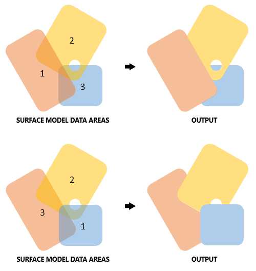
Exports nonoverlapping polygon features representing the deconflicted data area of each source dataset in a surface model.
Иллюстрация

Использование
This tool requires both the ArcGIS Spatial Analyst and an ArcGIS Desktop Advanced license.
The output of this tool depends on the ordering of the datasets within the given surface model. The order in which the datasets are sorted is determined by a surface model's rules and influences which datasets should supersede other datasets.
Two surface models, each with the same set of overlapping source datasets but ordered differently, will produce a different output when run through this tool.
The output of this tool can be joined with the output of the Export BIS Metadata tool to produce an effective dataset that can be symbolized by or identified for many of its metadata characteristics.
Синтаксис
ExportDeconflictedFootprints(bis_workspace, bis_model, out_features)
| Параметр | Объяснение | Тип данных |
bis_workspace | The Bathymetric Information System (BIS) from which the surface model's deconflicted footprints should be exported. This parameter accepts any geodatabase (.gdb) or enterprise database connection file (.sde) that has been registered as a BIS with the latest version. | Workspace |
bis_model | The name of the surface model from which to export the deconflicted footprints. | String |
out_features | The name and path given to the new polygon feature class that will be created. | Feature Class |
Пример кода
ExportDeconflictedFootprints example (Python window)
The following script demonstrates how to use the ExportDeconflictedFootprints tool.
# Name: ExportDeconflictedFootprints_Example.py
# Description: Export non-overlapping polygon features representing deconflicted data area of each dataset in the surface model
# Requirements: ArcGIS for Maritime Bathymetry, Spatial Analyst, ArcGIS for Desktop Advanced

import arcpy
arcpy.CheckOutExtension("Bathymetry")
arcpy.CheckOutExtension("Spatial")

# set up parameters
bis_workspace = "C:/Data/BIS.gdb"
bis_model = "Baja California"
out_features = "C:/Data/ModelOutputs.gdb/BajaCaliforniaFootprints"

# execute the tool.
arcpy.ExportDeconflictedFootprints_bathymetry(bis_workspace, bis_model, out_features)
Параметры среды
Информация о лицензиях
- Basic: Нет
- Standard: Нет
- Advanced: Требуется Maritime Bathymetry and Spatial Analyst