Доступно с лицензией Production Mapping.
Краткая информация
Extends the lengths and widths of polygon features until they meet a specified minimum value.
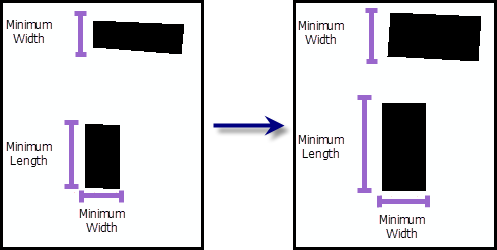
Иллюстрация

Использование
A warning is raised if the input features are not in a projected coordinate system. This tool relies on linear distance units, which will create unexpected results in an unprojected coordinate system. It is strongly suggested that you run this tool on data in a projected coordinate system to ensure valid results. An error is raised and the tool will not process if the coordinate system is missing or unknown.
Инструмент не может быть запущен с данными, который зарегистрированы как версионные.
It is recommended that this tool only be used on regular, rectangular-shaped polygons, such as buildings.
Features with a longer side smaller than the value specified in the Minimum_Length (Minimum Length) parameter will have the longer side extended until it meets the minimum value.
Features with a shorter side smaller than the value specified in the Minimum_Width (Minimum Width) parameter will have the shorter side extended until it meets the minimum value.
At a minimum, the Minimum_Length (Minimum Length) or Minimum_Width (Minimum Width) parameter must have a value defined since the default is 0. If a value is not defined, the input polygon feature will not be processed.
This tool cannot be run during an edit session.
Синтаксис
arcpy.production.ExtendPolygonSides(Input_Polygon_Features, {Minimum_Length}, {Minimum_Width})| Параметр | Объяснение | Тип данных |
Input_Polygon_Features | The polygon features that will have their lengths and widths extended. | Feature Layer |
Minimum_Length (Дополнительный) | The minimum size of the long side of the polygon. The default value is 0, meaning that the feature's length will not be extended. | Linear unit |
Minimum_Width (Дополнительный) | The minimum size of the short side of the polygon. The default value is 0, meaning that the feature's width will not be extended. | Linear unit |
Пример кода
ExtendPolygonSides example (stand-alone script)
The following stand-alone sample script demonstrates how to use ExtendPolygonSides.
# Name: ExtendPolygonSides_Example.py
# Description: Extends the sides of a building footprint until it is 150 feet
#   long and 100 feet wide
# Author: Esri
# Date: February 2014

# Import arcpy module
import arcpy

# Check out Production Mapping license
arcpy.CheckOutExtension("Foundation")

# set environment
arcpy.env.workspace="c:/data/LocalGovernment.gdb"

# Define variables
inFeatures="ReferenceData/BuildingFootprint"
where="FULLADDRESS='332 FORT HILL DR'"
minLength="150 feet"
minWidth="100 feet"

# make a feature layer
inFeatureLyr=arcpy.MakeFeatureLayer_management(inFeatures,"FacilityLayer",where)

# execute the ExtendPolygonSides function - best use against more rectangular features like buildings
arcpy.ExtendPolygonSides_production(inFeatureLyr,minLength,minWidth)
Параметры среды
Информация о лицензиях
- Basic: Нет
- Standard: Нет
- Advanced: Требуется Production Mapping