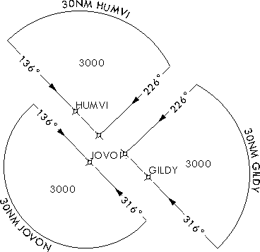
The Terminal Arrival Area (TAA) element appears in the plan view of an instrument approach procedure (IAP) and provides safe altitude and distance information. It contains three parts that reflect the straight-in, right-base, and left-base areas for the approach.

You can add this element to the map layout, as designated by your chart specification.
- Запустите ArcMap.
- On the main menu, click View > Layout View.
- Ensure that the TerminalProcedures table has been added to the table of contents.
- Open the Layer Properties dialog box and set a definition query such that the GFID matches the TerminalProcedure_ID value on the TAA feature class.
- On the main menu, click Customize > Toolbars > Aviation Terminal Procedure.
-
Click the Terminal Arrival Area button
 on the
Aviation Terminal Procedures toolbar.
The terminal arrival area element is added to the chart layout.