Доступно с лицензией Production Mapping.
The Grids and Graticules Designer uses annotation feature classes to display grid text. If the data frame properties (scale, extent, and rotation) are changed after a grid is created, the annotation properties will not automatically adjust to these changes.
Annotation components can be created from either points or endpoints. Preset styles are selected for you based on the coordinate system of the point or endpoint component from which the annotation is derived.
- Start ArcMap.
- On the main menu, click Customize > Toolbars > Production Cartography to add the Production Cartography toolbar.
- Click the Grids and Graticules Designer window button
 on the Production Cartography toolbar.
 - Create or load a grid that has endpoints or points.
- Right-click an endpoint or point component and click Add > Annotation.
The Annotation component is added to the tree view.
- Right-click the Annotation component in the tree view and choose Properties.
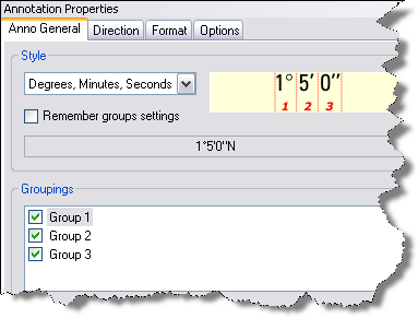
The Annotation Properties window appears.

- Choose a style from the Style list.
An example of each style appears to the right of the drop-down list.
- Configure other properties on this tab.
See Annotation styles for grids for information on each setting.
- Click the Direction tab.
- Type the number of units to use as an offset in the Offset X (-/+) text box.
- Type the number of units to use as an offset in the Offset Y (-/+) text box.
- Click the Units drop-down arrow and choose the unit of measurement for the offset.
- Choose an orientation option for the annotation in the Orientation area.
- If necessary, choose an option in the Rotation area.
- Optionally, change settings on the Format and Options tabs.