Доступно с лицензией Production Mapping.
Сводка
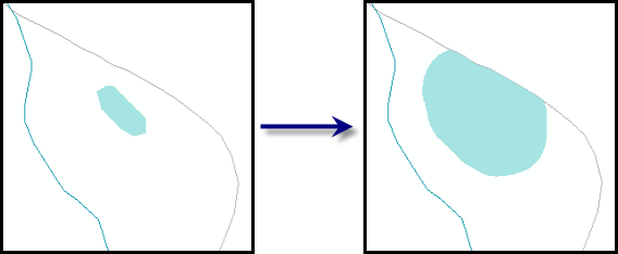
Increases the areas of polygons until they meet a minimum size or larger. You can optionally limit the features to be enlarged based on whether they intersect another feature class.
Иллюстрация

Использование
A warning is raised if the input features are not in a projected coordinate system. This tool relies on linear distance units, which will create unexpected results in an unprojected coordinate system. It is strongly suggested that you run this tool on data in a projected coordinate system to ensure valid results. An error is raised and the tool will not process if the coordinate system is missing or unknown.
Features are enlarged in all directions by applying a small buffer iteratively until the feature is larger than the minimum size. The resulting geometry will be larger than the minimum size and not equal to it.
If this tool is run in an edit session in ArcMap, you can stop the edit session without saving changes to restore features that have been deleted.
Синтаксис
arcpy.production.IncreasePolygonArea(Input_Polygon_Features, Minimum_Size, Buffer_Increase, {Intersect_Features}, {Barrier_Features})| Параметр | Объяснение | Тип данных |
Input_Polygon_Features | The polygon features to be enlarged. | Feature Layer |
Minimum_Size | The minimum area that features must meet. | Areal unit |
Buffer_Increase | The buffer value by which the area is increased for each feature. The buffer is applied until the feature reaches the minimum size. | Linear unit |
Intersect_Features (Дополнительный) | The features that intersect the input polygons. Input polygons that intersect are enlarged. | Feature Layer |
Barrier_Features [Barrier_Features,...] (Дополнительный) | The features that serve as a boundary for the polygon features when they are enlarged. This ensures that the features do not cross a barrier when they are enlarged; for instance, a pond does not cross a road. | Feature Layer |
Пример кода
IncreasePolygonArea example (stand-alone script)
The following stand-alone sample script demonstrates how to use Increase Polygon Area.
# Name: IncreasePolygonArea_Example.py
# Description: Increases park area to a minimum of 10,000 square feet.
# Author: Esri
# Date: February 2014

# Import arcpy module
import arcpy

# Check out Production Mapping license
arcpy.CheckOutExtension("Foundation")

# Set environment
arcpy.env.workspace="c:/data/LocalGovernment.gdb"

# Define variables
inFeatures="ReferenceData/FacilitySite"
inFeatureLyr="FaciltyLayer"
where="FCODE='Park'"
minArea="10000 SquareFeet"
bufferIncrease="100 Feet"

# Create a parks feature layer
arcpy.MakeFeatureLayer_management(inFeatures,inFeatureLyr,where)

# Execute IncreasePolygonArea
arcpy.IncreasePolygonArea_production(inFeatureLyr,minArea,bufferIncrease)
Параметры среды
Информация о лицензиях
- Basic: Нет
- Standard: Нет
- Advanced: Требуется Production Mapping