摘要
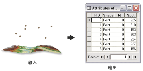
Calculates surface values for each point of a point feature class by interpolating from a raster, TIN, or terrain dataset surface.
Calculated values are added to the input feature class attributes.
插图

用法
Ensure the input surface and the input feature class have overlapping extents.
Use the {z_factor} argument to convert the output field to the desired units.
语法
SurfaceSpot_3d (in_surface, in_feature_class, {out_spot_field}, {z_factor}, {method}, {pyramid_level_resolution})| 参数 | 说明 | 数据类型 |
in_surface | The input raster, TIN, or Terrain dataset surface to be used for interpolation. | Terrain Layer; TIN Layer; Raster Layer |
in_feature_class | The input point feature class to which the interpolated values will be added. | Feature Layer |
out_spot_field (可选) | The name of the attribute field to be added to the input feature class. By default, the name is Spot. | String |
z_factor (可选) | The factor multiplied by the surface values to convert them to new values added to the input feature class. Used to convert z units to match x,y units. | Double |
method (可选) | Algorithm used to calculate surface values. | String |
pyramid_level_resolution (可选) | The resolution of the terrain dataset pyramid level to use for geoprocessing. The default is 0, full resolution. | Double |
代码示例
Surface Spot example 1 (Python window)
The following Python Window script demonstrates how to use the Surface Spotfunction in immediate mode.
import arcgisscripting
gp = arcgisscripting.create()

gp.CheckOutExtension("3D")
gp.workspace = "C:/data"
gp.SurfaceSpot_3d("elevation_tin", "points.shp", "SPOT", 3.28)
环境
许可信息
- ArcGIS Desktop Basic: 需要 3D Analyst
- ArcGIS Desktop Standard: 需要 3D Analyst
- ArcGIS Desktop Advanced: 需要 3D Analyst