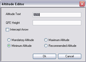
The Altitude Editor tool allows you to edit the altitude text by adding heights above the airport (QFE) and horizontal lines that indicate mandatory, minimum, and maximum altitudes. If a horizontal line is drawn by default when the instrument approach profile view is created, the Altitude Editor tool allows you to override the automated over/underlining.
- 启动 ArcMap。
- On the main menu, click View > Layout View.
- On the main menu, click Customize > Toolbars > Aviation Terminal Procedure.
- On the main menu, click Customize > Toolbars > Aviation Profile Edit.
-
Click the Edit Instrument Approach Profile button
 on the
Aviation Terminal Procedure toolbar.
- Select an altitude text element.

The Altitude Editor tool is enabled.
- Click the Altitude Editor button
 on the Aviation Profile Edit toolbar.
The Altitude Editor dialog box appears and is automatically populated with the selected altitude text.

- Type the altitude text you want to display.
- Click the appropriate option to specify whether the altitude is mandatory, minimum, maximum, or recommended.
- Type the QFE height if necessary.
- Check the Intercept Arrow check box if you want to add a glideslope intercept arrow to the instrument approach profile view.
- Click Ok.
The altitude text changes based on the parameters you defined.
