ArcGIS Desktop

  • 文档
  • 支持

  • My Profile
  • 帮助
  • Sign Out
ArcGIS Desktop

ArcGIS Online

专为贵组织打造的制图平台

ArcGIS Desktop

全面的专业性 GIS

ArcGIS Enterprise

面向企业的 GIS

ArcGIS for Developers

用于构建位置感知应用程序的工具

ArcGIS Solutions

适用于行业的免费模板地图和应用程序

ArcGIS Marketplace

获取适用于组织的应用程序和数据

  • 文档
  • 支持
Esri
  • 登录
user
  • 我的个人资料
  • 登出

ArcMap

  • 主页
  • 入门
  • 地图
  • 分析
  • 管理数据
  • 工具
  • 扩展模块

Accessing the metadata for selected datasets

Through the Explore Bathymetry tool, you can define filters based on the metadata values associated with the listed bathymetry datasets. You can also update the extended metadata values within the Explore Bathymetry window using the Edit Properties tool.

注:

Any extended metadata fields you update through the Edit Properties dialog box could potentially affect the current bathymetry dataset filter defined in the Explore Bathymetry window.

  1. Start ArcMap.
  2. On the main menu, click Customize > Toolbars > Bathymetry.
  3. Click the Explore Bathymetry button Explore Bathymetry on the Bathymetry toolbar.

    The Explore Bathymetry window appears. The right side of the window lists all bathymetry datasets from the active BIS geodatabase.
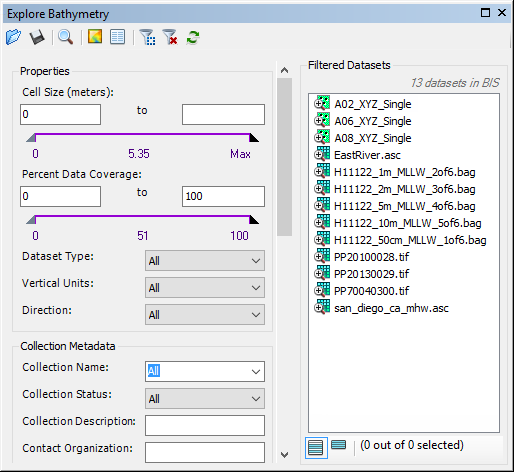
    Explore Bathymetry window
  4. To access the metadata for all datasets currently listed in the Filtered Datasets list, click the Edit Properties button Edit Properties at the top of the Explore Bathymetry window.

    注:

    You can select multiple datasets using the Shift or Ctrl keys. To access and edit metadata for only a particular dataset or group of datasets, right-click a dataset or selection and click Edit Properties or Edit Properties for Selected.

    The Edit Properties dialog box appears.
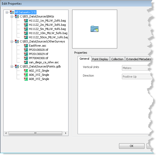
    Edit Properties dialog box
    注:

    The All Datasets parent node is highlighted by default. Any properties or metadata values that are shared by all datasets under this node will be reflected in the tab view. If values differ for the datasets in the dataset tree view, the value for that property or parameter will be shown as blank.

  5. Click one of the datasets in the gridded data tree view to highlight it.

    The previously defined general, point display, collection, extended, and internal metadata values are listed and viewable for the selected dataset.

    注:

    You can also click back to the All Datasets node or a dataset's parent folder to batch edit multiple datasets.

  6. Optionally update the applicable metadata fields on the Extended Metadata tab.

    注:

    General, point display, collection, and internal metadata values are read-only.

  7. Click Apply.

    The metadata updates are applied to the selected dataset.

  8. Optionally choose a different dataset listed in the gridded data tree view.
  9. Repeat steps 6 through 9.
  10. 单击确定。

相关主题

  • Bathymetry filters
  • Adding filtered bathymetry from the Explore Bathymetry window
  • Adding filtered bathymetry from the Compose Surface window

ArcGIS Desktop

  • 主页
  • 文档
  • 支持

ArcGIS 平台

  • ArcGIS Online
  • ArcGIS Desktop
  • ArcGIS Enterprise
  • ArcGIS for Developers
  • ArcGIS Solutions
  • ArcGIS Marketplace

关于 Esri

  • 关于我们
  • 招贤纳士
  • 内部人员博客
  • 用户大会
  • 开发者峰会
Esri
分享您的想法。
Copyright © 2018 Esri. | 隐私政策 | 法律声明