获得 Production Mapping 许可后可用。
The Open Geospatial Consortium (OGC) Web Feature Service (WFS) provides a way to make your maps and data available in an easily accessible and recognized format over the web. The WFS specification is an open specification for serving geographic features to anyone with a supported client application. You can publish a WFS service to ArcGIS Server by enabling the WFS capability when you publish a map or image service in ArcGIS Desktop.
To configure your WFS connection, follow these steps:
- 启动 ArcMap。
- Open the Catalog window.
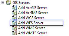
- Under GIS Servers, double-click Add WFS Server.

The Add WFS Server dialog box appears.
- Type the service URL.
- If applicable, enable service authentication and provide the username and password.
- If applicable, browse to a workspace schema XML that matches the data on the service.
This allows the usage of domains and subtypes if the workspace XML uses them. This is optional.
- Click Get Layers to preview what the service contains.
- 单击确定。