获得 Production Mapping 许可后可用。
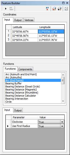
The Arc (End Points) function creates an arc, which can be used as part of a more complex polygon geometry. For aeronautical purposes, this function creates an RF leg according to ARINC Specification 424.

- 启动 ArcMap。
- On the menu bar, click Customize > Toolbars > Production Feature Builder.
- Click the Feature Builder button
 on the Production Feature Builder toolbar.
The Feature Builder window appears.
- If the scratch dataset has not been added to the table of contents, click the Add Scratch Data Layers button
 at the top of the Feature Builder window.
The dataset is added to the map using the current spatial reference.
- Choose Arc (End Points) in the list on the Functions tab.

- Define a coordinate for the start point of the polyline by doing one of the following:
- Click the Pinprick tool
 on the Production Feature Builder toolbar and click the map
 - Type the coordinates in the cells on the Input tab in the Coordinates area.
- Click the Pinprick tool
- Repeat step 6 to define a coordinate for the start point of the geodesic arc.
- Repeat step 5 to define a coordinate for the endpoint of the geodesic arc.
- If necessary, click the drop-down arrow next to Clockwise and choose False.
This indicates whether or not the arc is created in a clockwise direction. There are two options:
- True—The arc is created in a clockwise direction from the second input coordinate to the third input coordinate.
- False—The arc is created in a counterclockwise direction from the third input coordinate to the second input coordinate.
The default value is True, which creates the arc in a clockwise direction. Choosing False creates the arc in a counterclockwise direction.
- If necessary, click the drop-down arrow next to Use First Radius and choose False.
This is the radius for the arc, or the distance from the centerpoint to the arc's endpoints or start point. There are two options:
- True—The distance from the start point to the centerpoint is used to calculate the radius of the arc.
- False—The distance from the endpoint to the centerpoint is used to calculate the radius of the arc.
The default value is True, which uses the radius from the start point to the centerpoint. Choosing False uses the radius between the endpoint and the centerpoint.
- Click the Execute button
 .
.
An arc is created surrounding a central point.