需要 Geostatistical Analyst 许可。
摘要
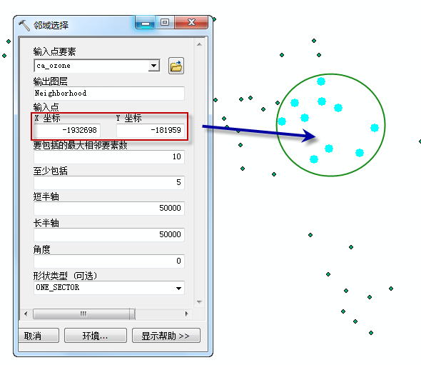
基于用户定义的邻域创建点图层。

例如,您可能要在输入点所定义的位置周围的圆形邻域创建点选择范围。上图显示了输出结果处于该圆形内的 10 个蓝色点。
用法
语法
GANeighborhoodSelection_ga (in_dataset, out_layer, point_coord, neighbors_max, neighbors_min, minor_semiaxis, major_semiaxis, angle, {shape_type})| 参数 | 说明 | 数据类型 |
in_dataset | 用于创建邻域选择的点。 | Feature Layer |
out_layer | 存储邻域选择的图层。 | Feature Layer |
point_coord | 邻域中心的 x,y 坐标。 | Point |
neighbors_max | 每个扇区中所要使用的点数。如果某个扇区具有所需点数,则使用该扇区中的所有点。 | Long |
neighbors_min | 每个扇区中所要使用的最小点数。如果任何指定扇区中的点数都没有达到所需的最小值,则会选择扇区之外最近的可用点。 | Long |
minor_semiaxis | 搜索邻域短半轴的尺寸。 | Double |
major_semiaxis | 搜索邻域长半轴的尺寸。 | Double |
angle | 邻域轴的旋转角度。 | Double |
shape_type (可选) | 邻域的几何。
| String |
代码示例
NeighborhoodSelection 示例 1(Python 窗口)
基于某项邻域标准创建要素图层。
import arcpy
from arcpy import env
env.workspace = "C:/gapyexamples/data"
arcpy.GANeighborhoodSelection_ga("ca_ozone_pts", "outNS", "-2000000 -50000",
                                 "20", "5","200000", "200000", "0", "One sector")
NeighborhoodSelection 示例 2(独立脚本)
基于某项邻域标准创建要素图层。
# Name: NeighborhoodSelection_Example_02.py
# Description: Creates a layer of points based on a user-defined neighborhood.
# Requirements: Geostatistical Analyst Extension

# Import system modules
import arcpy

# Set environment settings
arcpy.env.workspace = "C:/gapyexamples/data"

# Set local variables
inPoints = "ca_ozone_pts.shp"
outLayer = "outNS"
pointCoord = "-2000000 -50000"
maxNeighbors = 20
minNeighbors = 5
majSemiaxis = 200000
minSemiaxis = 200000
angle = 0
shape = "One Sector"

# Check out the ArcGIS Geostatistical Analyst extension license
arcpy.CheckOutExtension("GeoStats")

# Execute NeighborhoodSelection
arcpy.GANeighborhoodSelection_ga(inPoints, outLayer, pointCoord, maxNeighbors,
                                 minNeighbors, majSemiaxis, minSemiaxis, angle,
                                 shape)
环境
许可信息
- ArcGIS Desktop Basic: 需要 地统计分析
- ArcGIS Desktop Standard: 需要 地统计分析
- ArcGIS Desktop Advanced: 需要 地统计分析