获得 Production Mapping 许可后可用。
摘要
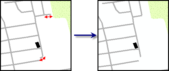
Removes lines that are shorter than the specified length and do not connect to other features on both ends.
插图

用法
A warning is raised if the input features are not in a projected coordinate system. This tool relies on linear distance units, which will create unexpected results in an unprojected coordinate system. It is strongly suggested that you run this tool on data in a projected coordinate system to ensure valid results. An error is raised and the tool will not process if the coordinate system is missing or unknown.
Input line features that are below the minimum length and do not touch another line at both end points are deleted.
If a maximum angle is entered, the dangles that are kept will be measured in length with a consecutive line. If the combined length is below the defined minimum length, both lines will be removed.
Features connected to any feature class listed in the Compare Features (Compare_Features for Python) parameter are not considered dangles.
If this tool is run in an edit session in ArcMap, you can stop the edit session without saving changes to restore features that have been deleted.
语法
DeleteDangles(Input_Line_Features, Minimum_Length, {Compare_Features}, Recursive, {Maximum_Angle})| 参数 | 说明 | 数据类型 |
Input_Line_Features | The features that will be checked for dangles. | Feature Layer |
Minimum_Length | The minimum length for input lines. Features shorter than this are deleted. | Linear unit |
Compare_Features [Compare_Features,...] (可选) | Additional features the input line features can be compared to when determining whether the feature is a dangle. | Feature Layer |
Recursive | Indicates the method used to delete dangles on the line features.
| Boolean |
Maximum_Angle (可选) | Any line below the minimum length that is within the defined angle of a consecutive line segment will be kept. | Double |
代码示例
DeleteDangles example (stand-alone script)
The following stand-alone sample script demonstrates how to use DeleteDangles.
# Name: DeleteDangles_Example.py
# Description: Uses Production Mapping tool Delete Dangles to remove
#   unconnected lines less than a certain length unless within a defined
#   angle.
# Author: Esri
# Date: December 2015

# Import arcpy module
import arcpy

# Check out Production Mapping license
arcpy.CheckOutExtension("Foundation")

# set environment
arcpy.env.workspace="c:/data/LocalGovernment.gdb"

# Define variables
inFeatures="ReferenceData/RoadCenterline"
inCompareFeatures="ReferenceData/Hospital"
inFeaturesLyr="RoadL_Lyr"
inCompareFeaturesLyr="Hospital_Lyr"
recursion = 'NON_RECURSIVE'
minLength="10 Feet"
maxAngle="45"

# Create an input feature layer for DeleteDangles
arcpy.MakeFeatureLayer_management(inFeatures,inFeaturesLyr)
arcpy.MakeFeatureLayer_management(inCompareFeatures, inCompareFeaturesLyr)

# Execute the tool
arcpy.DeleteDangles_production(inFeaturesLyr,minLength,inCompareFeaturesLyr,recursion,maxAngle)
环境
许可信息
- ArcGIS Desktop Basic: 否
- ArcGIS Desktop Standard: 否
- ArcGIS Desktop Advanced: 需要 Production Mapping