获得 Production Mapping 许可后可用。
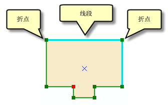
You digitize a new line of a polygon feature's shape by drawing an edit sketch, which is the underlying representation of the feature's geometry. As you sketch, you see a preview with the actual symbology used for that template, with the vertices symbolized as red and green squares.
A sketch is composed of all the vertices and segments of the feature. Vertices are the points at which the sketch changes direction, such as corners; segments are the lines that connect the vertices.

The following composite construction tools can be used to create line and polygon features from composite templates:
| Construction tool name | Sketch type |
|---|---|
Coincident Lines | Line |
Coincident Polygons | Polygon |
Polygon/Line | Polygon |
Point at Polygon Center | Polygon |
Point at Polygon Start | Polygon |
Point at Line Start or End | Line |
Point at Line Center | Line |
Points at Polygon Vertices | Polygon |
Points at Line Vertices | Line |
- 启动 ArcMap。
- 如有必要,可在地图中加载数据。
- 在主菜单上,单击自定义 > 工具条 > 生产编辑。
- 单击生产编辑工具条上的启动生产编辑按钮
 。
。
- Click the Create tab on the Manage Features window.
- Choose a composite template with at least one line or polygon layer on the Create tab on the Manage Features window.
A construction tool is selected by default.
- Choose a construction tool.
- Click the map or provide the proper inputs to build the sketch.
- Finish the sketch to create the feature.