获得 Business Analyst 许可后可用。
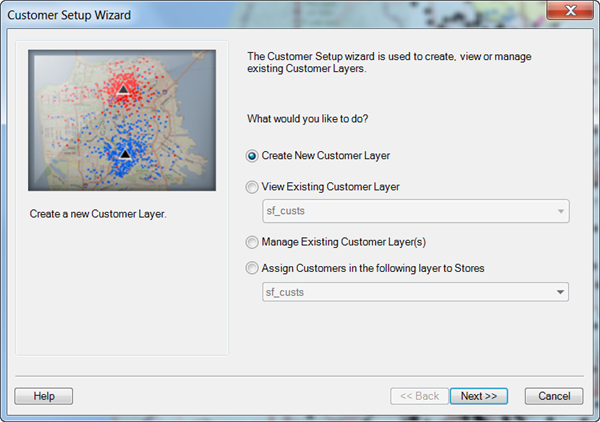
The Customer Setup wizard helps you create, view and manage your own customer data. You can create a customer layer from a variety of methods as well as view and manage existing customer layers. You can also assign customers to a store layer.

Create New Customer Layer
You can create a new customer layer with the following methods:
- Tabular data - Choose this option if your customer data is in a tabular format such as a spreadsheet or .dbf file.
- Map-ready data - Choose this option if your data is contained in a standard ArcGIS file format such as a shapefile or geodatabase.
- Create an empty layer - Choose this option to create an empty customer layer so that you can manually build your customer attribute table and place locations on the map.
- Enter customers' addresses - Choose this option to manually add customer addresses one at a time and create a customer layer.
- XY/GPS data - Choose this option to add customer locations by longitude (x) and latitude (y) coordinates in decimal degrees and create a customer layer.
Run Address Coder - Choose this option to create a customer layer while appending additional demographic attributes during the geocoding process or when using advanced selection options. See the Address Coder help for more information.
Confirm that the analysis extent is set as you want. Any layer added to the map while an extent is active will be associated with that analysis extent.
After the customer layer has been created, a File Geodatabase of your data is created and stored in the \My Output Data\Projects\Your Project\CustLayers folder.
For users with a Business Analyst Premium license, at the end of the Customer Setup wizard, an option to create a customer profile using Tapestry segmentation data is available.
- Append segmentation codes to address records - A Tapestry segmentation code is appended to each record of the attribute table in the customer layer. Using the block group code, obtained during the geocoding process, Business Analyst appends the associated dominant Tapestry code of the block group. The dominant Tapestry code is defined as the Tapestry segment with the highest number of households in a geography.
- Create a customer profile - Choose this option to create a profile that can be used in the target marketing reports, charts, and maps.
View Existing Customer Layer
Promotes any available customer layer to the top for easier viewing and selecting.
Manage Existing Customer Layer(s)
You can manage the customer layers that you have created. This allows you to perform the following operations on any of your previously created customer layers:
- Open a layer that is not present in the current map document.
- Modify a layer by stepping through the Customer Setup wizard choices made when the layer was created.
- Rename a layer or edit comments.
- Review geocoding of the layer points on the map.
- Assign customers to stores.
- Delete one or more layers.
Assign Customers to Stores
You can assign a customer layer to a stores layer by ascribing a store ID to each customer record by one of three methods:
- By closest store location - choose this option if you want to exclude any other factor, other than distance, when determining a stores' customers.
- By trade area - choose this option if you want derive optimal trade areas for your stores and then assign customers based on that criteria.
- By using my assignments - manually choose which customers are assigned to which store.