ArcGIS Desktop

  • ArcGIS Pro
  • ArcMap

  • My Profile
  • 帮助
  • Sign Out
ArcGIS Desktop

ArcGIS Online

专为贵组织打造的制图平台

ArcGIS Desktop

全面的专业性 GIS

ArcGIS Enterprise

面向企业的 GIS

ArcGIS Developers

用于构建位置感知应用程序的工具

ArcGIS Solutions

适用于行业的免费模板地图和应用程序

ArcGIS Marketplace

获取适用于组织的应用程序和数据

  • 文档
  • 支持
Esri
  • 登录
user
  • 我的个人资料
  • 登出

ArcMap

  • 主页
  • 入门
  • 地图
  • 分析
  • 管理数据
  • 工具
  • 扩展模块

Modifying the color ramp

The Manage BIS Settings tool allows you to set a default local color ramp for data visualized in the Explore Bathymetry and Compose Surface windows. For bathymetry data, a color ramp applies a range of colors to the range of depth values associated with a surface model. ArcGIS Bathymetry provides you with standard color ramps used within the bathymetric community.

注:

Changes made to the default local color ramp will only be visible on the local machine that the changes were made on. This setting does not affect other users or machines connected to the BIS geodatabase.

  1. 启动 ArcMap。
  2. Click Customize > Toolbars > Bathymetry on the main menu to activate the Bathymetry toolbar if necessary.
  3. Click the Manage BIS Settings button Manage BIS Settings on the Bathymetry toolbar.

    The Manage BIS Settings dialog box appears. The settings for your active BIS geodatabase are shown in this dialog box.

    Manage BIS Settings dialog box
  4. Click the Display pane.
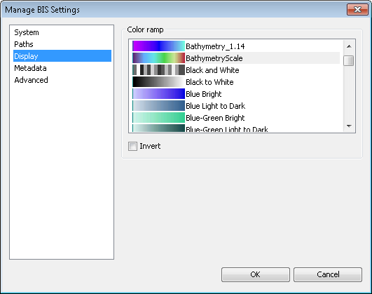
    Manage BIS Settings dialog box Display pane
  5. In the Color Ramp section, choose the color ramp that you want to use to visualize data in the Explore Bathymetry and Compose Surface windows.

    Modifying the color ramp will not automatically update the thumbnail previews of the data or the color ramp in ArcMap.

    提示:

    You can quickly jump to any of the available color ramps by selecting a color ramp and typing the first letter of the color ramp name. For example, to find a specific blue color ramp, click a color ramp and type the letter B multiple times to scroll through the list of blue color ramps.

  6. Optionally, check the Invert check box to insert the color ramp.

    Any mosaic dataset previews created after this check box is checked will be generated using the inverted color ramp.

  7. 单击确定。

相关主题

  • Modifying the BIS system settings

ArcGIS Desktop

  • 主页
  • 文档
  • 支持

ArcGIS

  • ArcGIS Online
  • ArcGIS Desktop
  • ArcGIS Enterprise
  • ArcGIS
  • ArcGIS Developer
  • ArcGIS Solutions
  • ArcGIS Marketplace

关于 Esri

  • 关于我们
  • 招贤纳士
  • Esri 博客
  • 用户大会
  • 开发者峰会
Esri
分享您的想法。
Copyright © 2021 Esri. | 隐私政策 | 法律声明