ArcGIS Roads and Highways can persist referent locations and measures with events, in addition to the route ID and measures. This is particularly useful for honoring event locations that are input as referent and offset, as opposed to relocating events after a cartographic realignment based on the new location of the event route ID and measure.
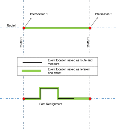
As shown in the diagram below, there are two line events on Route 1 that are located between Intersection 1 and Intersection 2. The event represented by the thin black line has from and to measures stored in the form of route ID and measures, whereas the event represented by the thicker green line has from and to measures stored in the form of referent and offset values in addition to route ID and measures.
Roads and Highways provides an option for changing the measure length of a route as a product of cartographic realignment of the route to reflect the change in geometric length. Therefore, when a cartographic realignment takes place to fix the shape of Route 1, the measures on the event represented by the thin black line remain intact even though the measure length of the route has increased and the resulting event does not touch Intersection 2 anymore. The event has lost its location relative to Intersection 2.
The event represented by the thicker green line changes its measure per its relation to the referent and offset values. Here, the location of the intersections remains intact; therefore, the resulting event is still located between Intersection 1 and Intersection 2.

In addition to route ID and measures, the events can have columns to store information about any referent location provided as data entry in ArcGIS Event Editor to derive the location of the event. The referent locations that can be stored include the following:
- Offset distance from any point feature in the geodatabase
- Offset distance from a Roads and Highways intersection point feature
- Offset distance from a Roads and Highways point event feature
- Offset distance from an x,y coordinate
- Offset distance from a station
To leverage this feature, additional columns must be configured with your events to include columns for the referent method, the referent location, and the referent offset. For linear events, there are two sets of these columns, one for the from measure and one for the to measure, as shown in the table below. For point events, only one set of the new columns is required. For more information, see Events data model.
You need to manually add these columns to the table before registering an event that stores referent offset values.
The next sections describe the properties of the newly added columns.
Referent method
This column stores the methodology provided for referencing the event location. When using Roads and Highways to provide a measure for an event by providing an intersection offset, x,y coordinate offset, feature and offset, event and offset, or starting station and offset, the provided referent location and offset will be stored with the event along with the calculated route and measures. In addition, events in the same layer can have different referent methods. For example, a crash event in the layer can be located by x,y coordinate offset and another crash in the same event layer can be located by intersection and offset.
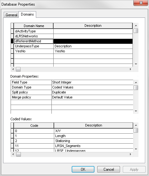
The referent method information is stored in a coded value domain named dReferentMethod in the geodatabase. This domain is created automatically when creating the LRS with the following default values:
- Code 0 for x,y location offset
- Code 1 for length distance from a point location
- Code 2 for stationing offset

The rest of the coded values are added automatically when you add a network, register a line or point event, create an LRS intersection class, or add a stationing event.
Referent location
This column stores the referent location information for locating the feature. The following table describes the type of information stored in this field:
| If the referent method is | The referent location field stores |
|---|---|
Route ID and Measure | Measure |
Intersection and Offset | Intersection ID |
Event ID and Offset | Event ID |
Feature Class and Offset | Object ID |
X,Y Coordinates | Comma-separated coordinates |
A Station Measure (relative to a Station Event layer) | Referent station Event ID |
Starting Station and Offset | Referent station Event ID |
Referent offset
This column stores the offset measure from the referent location. The following table describes the type of information stored in this field:
| If the referent method is | The referent offset field stores |
|---|---|
Route ID and Measure | Measure |
Intersection and Offset; Event and Offset; X,Y Coordinates; or Feature Class and Offset | Offset as a negative or positive value (compass directions provided by the user are translated to + or – offsets at storage) |
A station measure (relative to a Station Event layer) or Starting Station and Offset | User-supplied station measure in the station format (for example, 100+22.65) |
The units of measure for storage are configured at the time of registering the event layer.