在 Basic 版中某些功能受限。
获得 Business Analyst 许可后可用。
描述
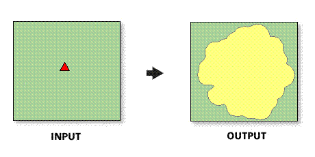
Creates a new feature class of trade areas, based on drive time, driving distance, or other travel modes, around store point features.
插图

使用方法
The spatial reference of the output feature class will be the same as the store layer.
Drive-time distances should be limited to 90 minutes. Realistic analyses beyond this threshold should be run using static rings.
The drive time center input feature class must be point features.
In most cases, the drive time center input feature layer will be a Business Analyst store layer.
Valid numeric distances must be used when defining drive-time values. Negative distances cannot be used.
Selecting ALL in Sites To Use will create rings for each point feature in the ring centers (stores) input feature class.
The projection of the input ring centers feature class will be copied to the output feature class.
Donut rings create output polygons that are bands. For example, if three radii are entered with values of 1, 2, and 3 miles, three output bands would be created with 0–1-, 1–3-, and 3–5-minute drive time trade areas.
Set the measure units to minutes if you want to create drive time trade areas.
Displaying traversed streets with street attribute fields attached can be useful when labeling feature classes.
To compensate for traffic patterns in drive-time analyses, adjust driving distances accordingly. For example, if you are looking at a time of day when traffic patterns are heavy (such as rush hour) and the drive time takes twice as long, then you can halve the drive time to reflect this pattern.
You can change the speed settings for different road classifications on the Business Analyst Preferences Data tab.
You can create more advanced drive-time polygons with custom road networks, adding barriers, and the like with the ArcGIS Network Analyst tools.
The Detailed border option allows you to draw drive-time boundaries that will ignore areas that cannot be driven to. This may create holes in your drive-time boundary file.
语法
arcpy.ba.DriveTime(InputFeatureLayer, IDField, All_Or_Single_Or_Selected, Radius, {MeasureUnits}, OutputFeatureClass, {ByID_Or_ByName}, {Single_Site}, {Donut}, {BorderShape}, {RemoveOverlap}, {UseSMDT}, {ShowTraverceStreets}, {JoinStreetAttr}, {OutTraveseFeatureClass}, {Solver_Id}, {BarrierFeatureClasses}, {TravelMode})| 参数 | 说明 | 数据类型 |
InputFeatureLayer | The input feature class containing center points for the drive time trade areas. In most cases, this will be a Business Analyst store layer. | Feature Layer |
IDField | Unique ID field in the ring center (store) layer. | Field |
All_Or_Single_Or_Selected | Creates drive time trade areas for points in the input feature layer.
| String |
Radius [Radius,...] | The distances, in ascending size, used to create drive time trade areas around the input features. | Double |
MeasureUnits (可选) | The units used with the distance values. By default, the units defined in the Business Analyst preferences will be selected.
| String |
OutputFeatureClass | The feature class that will contain the drive-time features. | Feature Class |
ByID_Or_ByName (可选) | Field used to select a single point.
| String |
Single_Site (可选) | ID or name of store to be used as the single point. | String |
Donut (可选) | Creates nonoverlapping concentric rings, or donut bands.
| Boolean |
BorderShape (可选) | Creates a detailed border, ignoring areas that cannot be driven to.
| Boolean |
RemoveOverlap (可选) | Creates overlapping concentric rings or removes overlap.
| Boolean |
UseSMDT (可选) | Generates drive times based on the Street Map algorithm. These drive times will be generated more quickly in large areas as compared to the default Network Analyst drive times.
| Boolean |
ShowTraverceStreets (可选) | The feature class that contains all the streets contained by the drive-time polygon derived from the streets feature class.
| Boolean |
JoinStreetAttr (可选) | Joins the attribute field from the streets layer to the new drive time traversed streets that will contain the traversed drive-time network for each drive time trade area.
| Boolean |
OutTraveseFeatureClass (可选) | The feature class that will contain the traversed streets. | Feature Class |
Solver_Id (可选) | The method to calculate drive time or travel mode.
| String |
BarrierFeatureClasses [BarrierFeatureClasses,...] (可选) | Allows a user to place point, line, or polygon barriers when using drive time or drive distance algorithms to calculate distances. | Feature Layer |
TravelMode [TravelMode,...] (可选) | Allows a user to select other methods of travel and travel distances. | String |
代码示例
DriveTime example (stand-alone script)
# Name: DriveTime.py
# Description: Generates a 1, 3, and 5 mile drive time in minutes around a store site in San Francisco.
# Author: Esri

# Import system modules
import arcview
import arcpy

arcpy.ImportToolbox(r"C:\Program Files (x86)\ArcGIS\Desktop10.8\Business Analyst\ArcToolbox\Toolboxes\Business Analyst Tools.tbx")

# Acquire extension license
arcpy.CheckOutExtension("Business")
arcpy.CheckOutExtension("Network")

# Define input and output parameters for the Drive Time tool
InputFeatureLayer = "C:/temp/sf_store.shp"
IDField = "STORE_ID"
OutputFeatureClass = "C:/temp/Drivetime.shp"
All_Or_Single_Or_Selected = "ALL"
Radius = "1;3;5"
MeasureUnits = "Minutes"

# Create drive time based trade areas
arcpy.DriveTime_ba(InputFeatureLayer,
						IDField,
						OutputFeatureClass,
						All_Or_Single_Or_Selected,
						Radius,
						MeasureUnits)

# Release extension license
arcpy.CheckInExtension("Business")
arcpy.CheckInExtension("Network")
环境
此工具不使用任何地理处理环境。
许可信息
- Basic: 需要 Business Analyst
- Standard: 需要 Business Analyst
- Advanced: 需要 Business Analyst