获得 Business Analyst 许可后可用。
Use the Create Profile By Table Geocoding tool when you want to create profiles based on address data.
For example, suppose you want to create a Customer Tapestry Profile Report for a set of customers around a given store location. In Business Analyst, you can create a customer-derived trade area using the locations of each customer in relation to the store location. For example, you could create a trade area that represents the closest 80 percent of customers around the store location. This type of trade area is often referred to as the store's primary trade area. Once the trade area is created, you can use the Create Profile By Area Summation tool to create a segmentation profile of the primary market area. When you create the Customer Tapestry Profile Report, you can compare the profile of your customer locations to the primary market area.
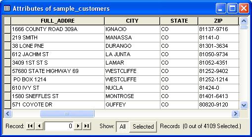
The table below illustrates how an address table may look. In the Create Profile By Table Geocoding tool, the Input Address Fields will be set to the fields below.

Using the address information from your file, Business Analyst can append a Tapestry segment to each matched address. The most accurate match level is the street address or ZIP+4 match level. If a record cannot be matched at the street address or the ZIP+4 level, a census tract code is assigned with a ZIP Code-to-Census Tract correspondence. This means that the census tract with the largest population in the ZIP Code is appended to the customer record. This match is described as the Dominant Tract in ZIP Code match level. If the ZIP Code contains only one census tract, the match level is One Tract in ZIP Code. If an address received a No Geocode designation, no match was possible below the county geographic level. Post office boxes, rural routes, rural drops, or incomplete addresses can prevent a match.