The linear referencing system (LRS) supports temporality by establishing from and to dates for all LRS elements. When LRS Networks and event layers are displayed on a map, they are always associated with a specific date and time stamp. This date and time stamp is referred to as the temporal view date (TVD). The TVD is set to your computer's current system date and time by default. You can change the TVD of Network, Event, and Calibration Point layers in two ways:
Learn more about setting the TVD from the Roads and Highways toolbar
Learn more about setting the TVD from the Layer Properties dialog box
Setting the TVD from the Roads and Highways Editing toolbar
This method is helpful when changing the TVD of all the layers (Network, Event, and Calibration Point) in an MXD at once.
- Start ArcMap and open your MXD containing the LRS layers.
- Click the Set Date Filter button
 on the Roads and Highways toolbar.
You can hover over the Set Date Filter tool
 to see the current TVD setting.
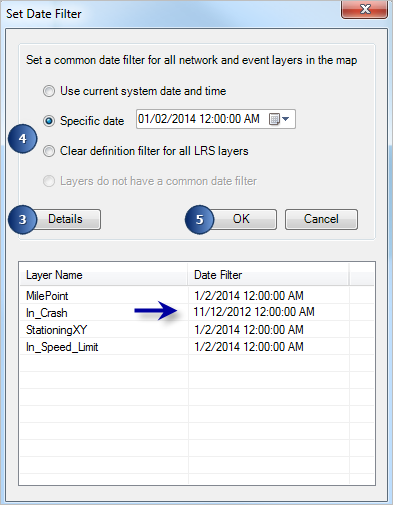
The Set Date Filter dialog box appears.

- Click Details.
The list of the LRS layers present in the .mxd appears with their individual TVDs.
- You have two choices to set a common date filter for all the LRS layers present in the map.
- Choose the Use current system date and time option to set the TVD from the system's current date and time.
- Choose the Specific date option to specify a TVD.
- Click OK.
The selected TVD is set for all the LRS layers present in the .mxd and the Set Date Filter dialog box disappears.
- To clear the TVD from the LRS layers, click Clear definition filter for all LRS layers.
This option removes all definition filters from the LRS layers including networks, intersections, and calibration points.
Setting the TVD from the Layer Properties dialog box
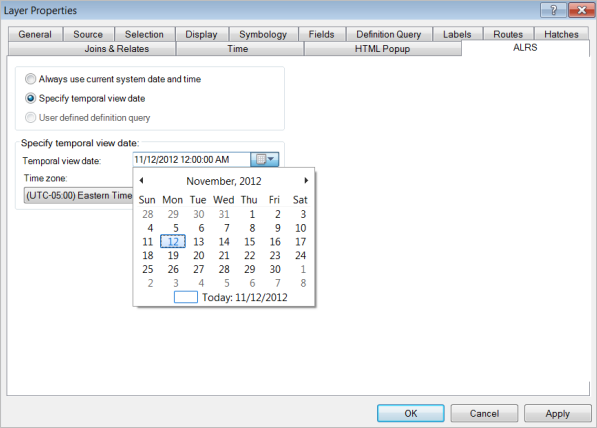
You can change the TVD for each individual layer in your map by opening the Layer Properties dialog box and clicking the ALRS tab.
- Запустите ArcMap.
- Add LRS Networks and LRS event layers to your map.
- Right-click the LRS Network or event layer in the table of contents and click Properties.
The Layer Properties dialog box appears.
- Click the ALRS tab on the Layer Properties dialog box.
- Click the Specify temporal view date option.
- Click the Temporal view date calendar and choose a TVD.

- Нажмите кнопку Применить (Apply).
- Нажмите ОК.