ArcGIS Desktop

  • ArcGIS Pro
  • ArcMap

  • ArcGIS Pro
  • ArcMap
ArcGIS Desktop

ArcGIS Online

Die Mapping-Plattform für Ihre Organisation

ArcGIS Desktop

Ein vollständiges professionelles GIS

ArcGIS Enterprise

GIS in Ihrem Unternehmen

ArcGIS for Developers

Werkzeuge zum Erstellen standortbezogener Apps

ArcGIS Solutions

Kostenlose Karten- und App-Vorlagen für Ihre Branche

ArcGIS Marketplace

Rufen Sie Apps und Daten für Ihre Organisation ab.

  • ArcGIS Pro
  • ArcMap
Esri
English
  • English
  • Deutsch
  • Español
  • Français
  • 日本語
  • Русский
  • 简体中文
  • Anmelden
user
  • Eigenes Profil
  • Abmelden

ArcMap

  • Startseite
  • Erste Schritte
  • Karte
  • Analysieren
  • Verwalten von Daten
  • Werkzeuge
  • Mehr...
  • Mehr...
  • Erweiterungen
  • Production Mapping
  • Mapping, charting, and visualization
  • Creating and deriving cartographic data
  • Generating product-specific grids
  • Designing a custom grid
  • Oben
  • What is Grids and Graticules?
  • A quick tour of the Grids and Graticules Designer
  • Essential grids and graticules vocabulary
  • Designing a custom grid

    • Key grid concepts
    • Adding a new grid
    • Creating new grids
    • Creating the neatline
    • Configuring grid segments
    • Creating grid lines
    • Creating points
    • Generating endpoints
    • Creating corner ticks
    • Creating regular ticks
    • Creating grid annotation
    • Editing grid components
    • Removing grid components
    • Validating grid components
    • Saving grids
    • Upgrading 9.3.1 grids to 10.x

    Managing grids in the map

    • Adding grid data to the map
    • Masking grids
    • Selecting grid components
    • Applying the grid layout view

    Validating grid components

    Diese ArcGIS 10.3-Dokumentation wurde archiviert und wird nicht mehr aktualisiert. Inhalt und Links sind möglicherweise veraltet. Verwenden Sie die aktuelle Dokumentation.

    The Validate command performs logical checks against a grid or selected grid component. Errors found by validate appear in a dialog box. You can double-click an item in the dialog box to display the component's properties and fix the error. Unfixed errors appear with red icons in the Grids and Graticules Designer window. For example, if annotation in a grid produces errors during validation, it appears with a red A in the Grids and Graticules Designer window.
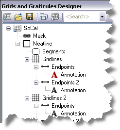
    The Grids and Graticules Designer window displaying an annotation error
    1. Start ArcMap.
    2. If necessary, load data in the map.
    3. On the main menu, click Customize > Toolbars > Production Cartography.
    4. Click the Grids and Graticules Designer window button Grids and Graticules Designer window on the Production Cartography toolbar.

      The Grids and Graticules Designer window appears.

    5. Create a new grid or click the Open button Open to load a grid XML into the Grids and Graticules Designer window.
    6. Right-click the grid component you want to validate and click Validate.

      If no errors are found, a message appears stating No errors found during validation.

      If errors are found, the Found errors dialog box appears.

      The Found errors dialog box
    7. Double-click the component in the Found errors dialog box.

      The component's properties window appears. For example, double-clicking the Grid [SoCal] component shown in the graphic in step 6 displays the Grid General tab of the Grid Properties window.

    8. Fix the errors identified in the Found errors dialog box.
    9. Repeat steps 6–8 until no errors are found during validation.

    Verwandte Themen

    • What is Grids and Graticules?
    • A quick tour of the Grids and Graticules Designer
    • Saving grids
    • Editing grid components
    • Removing grid components

    ArcGIS Desktop

    • Startseite
    • ArcGIS Pro
    • ArcMap
    • Dokumentation
    • Support

    ArcGIS

    • ArcGIS Online
    • ArcGIS Desktop
    • ArcGIS Enterprise
    • ArcGIS Platform
    • ArcGIS Developer
    • ArcGIS Solutions
    • ArcGIS Marketplace

    Über Esri

    • Über uns
    • Karriere
    • Insider-Blog
    • User Conference
    • Developer Summit
    Esri
    Copyright © 2017 Esri. | Datenschutz | Rechtliches