ArcGIS Desktop

  • Dokumentation
  • Support

  • My Profile
  • Hilfe
  • Sign Out
ArcGIS Desktop

ArcGIS Online

Die Mapping-Plattform für Ihre Organisation

ArcGIS Desktop

Ein vollständiges professionelles GIS

ArcGIS Enterprise

GIS in Ihrem Unternehmen

ArcGIS for Developers

Werkzeuge zum Erstellen standortbezogener Apps

ArcGIS Solutions

Kostenlose Karten- und App-Vorlagen für Ihre Branche

ArcGIS Marketplace

Rufen Sie Apps und Daten für Ihre Organisation ab.

  • Dokumentation
  • Support
Esri
  • Anmelden
user
  • Eigenes Profil
  • Abmelden

ArcMap

  • Startseite
  • Erste Schritte
  • Karte
  • Analysieren
  • Verwalten von Daten
  • Werkzeuge
  • Erweiterungen

Loading a surface model

The BIS geodatabase stores all of your composite surface models and allows you to load them into the Compose Surface window through the Load Surface Model tool. Through this tool, you can select the specific surface model you want to load along with the particular version. You can load older versions of a surface model to review the dataset display configurations. The older versions of a surface model are read-only, but you can use the Save Surface Model As tool to create a new surface model based on the dataset display configurations of the older surface model version.

  1. Start ArcMap.
  2. On the main menu, click Customize > Toolbars > Bathymetry.
  3. Click the Compose Surface button Compose Surface on the Bathymetry toolbar.

    The Compose Surface window appears.

  4. Click the Load Surface Model button Load Surface Model located at the top of the Compose Surface window.

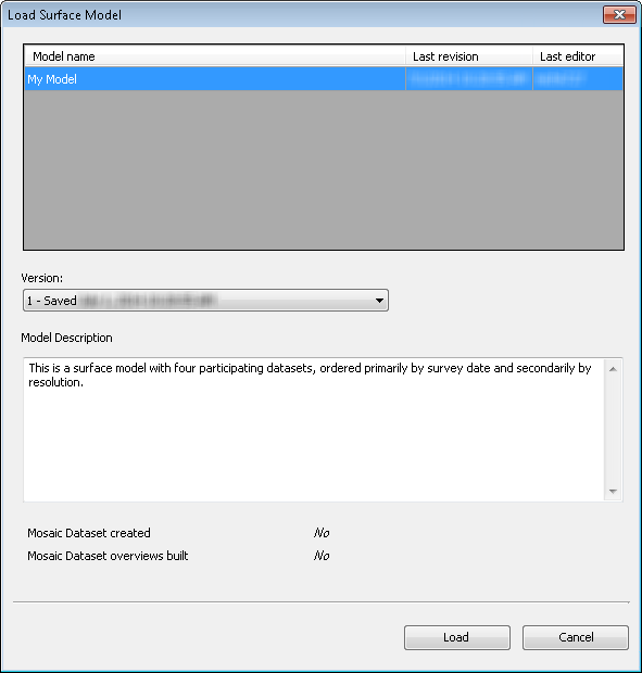
    The Load Surface Model dialog box appears. A list of saved surface models and basic metadata for the surface model is displayed.

  5. Load Surface Model dialog box
  6. Optionally click the Version drop-down arrow and select the specific version of the surface model you want to view.

    Hinweis:

    Versions are only available if you are working with an archive-enabled, versioned Enterprise-Geodatabase.

  7. Select the surface model that you want to load into the Compose Surface window.
  8. Hinweis:

    You can view the model description in the Model Description text box to confirm that the model you have selected is the one you want to load into the Compose Surface window.

  9. Click Load to load the surface model into the Compose Surface window.

    Surface rules and datasets associated with the surface model appear in the Compose Surface window. If a mosaic dataset was saved with the surface model, it is automatically added to the Table Of Contents window in ArcMap and checked on so that it is visible and displayed within the active data frame.

  10. Optionally, if a mosaic dataset has not been created for the surface model, click the Preview button Preview located at the top of the Compose Surface window.

    Clicking the Preview button Preview generates a temporary mosaic dataset and automatically adds it to the ArcMap Table Of Contents window.
    Hinweis:

    The mosaic dataset generated by the Preview tool has approximate values calculated for the Min, Max, Mean, and Standard Deviation raster statistics fields and should not be used for analysis. In addition, the preview also has a Stretch Type parameter of the Stretch function configured for Minimum-Maximum, which will include all pixel values, even outliers. If you need to generate precise statistics or exclude outlying pixel values, it is highly recommended that you use the Calculate Statistics tool and configure the Stretch function parameters to meet your requirements.

Tipp:

To close a surface model, click the Close Composite Surface button Close Surface Model located at the top of the Compose Surface window. If a composite surface was added to the Table Of Contents window, it will also be removed.

Verwandte Themen

  • Composing a surface model
  • Loading a rule file
  • Saving a surface model
  • Managing surface models

ArcGIS Desktop

  • Startseite
  • Dokumentation
  • Support

ArcGIS Plattform

  • ArcGIS Online
  • ArcGIS Desktop
  • ArcGIS Enterprise
  • ArcGIS for Developers
  • ArcGIS Solutions
  • ArcGIS Marketplace

Über Esri

  • Über uns
  • Karriere
  • Insider-Blog
  • User Conference
  • Developer Summit
Esri
Wir sind an Ihrer Meinung interessiert.
© Copyright 2016 Environmental Systems Research Institute, Inc. | Datenschutz | Rechtliches