ArcGIS Desktop

  • ArcGIS Pro
  • ArcMap

  • My Profile
  • Hilfe
  • Sign Out
ArcGIS Desktop

ArcGIS Online

Die Mapping-Plattform für Ihre Organisation

ArcGIS Desktop

Ein vollständiges professionelles GIS

ArcGIS Enterprise

GIS in Ihrem Unternehmen

ArcGIS for Developers

Werkzeuge zum Erstellen standortbezogener Apps

ArcGIS Solutions

Kostenlose Karten- und App-Vorlagen für Ihre Branche

ArcGIS Marketplace

Rufen Sie Apps und Daten für Ihre Organisation ab.

  • Dokumentation
  • Support
Esri
  • Anmelden
user
  • Eigenes Profil
  • Abmelden

ArcMap

  • Startseite
  • Erste Schritte
  • Karte
  • Analysieren
  • Verwalten von Daten
  • Werkzeuge
  • Erweiterungen

Calculate Areas

  • Zusammenfassung
  • Abbildung
  • Verwendung
  • Syntax
  • Codebeispiel
  • Umgebungen
  • Lizenzinformationen

Zusammenfassung

Calculates area values for each feature in a polygon feature class.

Ältere Versionen:

Because there are easier and more efficient ways to get the area of features, the Calculate Areas tool has been deprecated. Use the Calculate Field tool or the Geometry Calculator instead of the Calculate Areas tool in your workflows and custom script or models tools. If you are using feature classes in a geodatabase, the shape_area attribute field is maintained for you automatically.

Abbildung

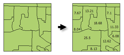
Calculate Areas illustration

Verwendung

  • The F_AREA field created in the Output Feature Class will be populated with values for the area of each polygon feature in square units of the Output Coordinate System.

  • There are alternative methods for creating an Area field for polygon features including: Calculate Field and the Geometry Calculator.

  • The Output Feature Class is a copy of the Input Feature Class with the additional (or updated) F_AREA field containing polygon areas.

  • Vorsicht:

    The F_AREA field is created in the Output Feature Class to store calculated Area values. If a field of this name already exists in the Input Feature Class, it will be overwritten in the Output Feature Class.

    Vorsicht:

    Denken Sie beim Verwenden von Shapefiles daran, dass diese keine NULL-Werte speichern können. Werkzeuge oder andere Verfahren zur Erstellung von Shapefiles aus Nicht-Shapefile-Eingaben speichern oder interpretieren NULL-Werte möglicherweise als Wert 0. In manchen Fällen werden NULL-Werte in Shapefiles als sehr große negative Werte gespeichert. Dies kann zu unerwarteten Ergebnissen führen. Weitere Informationen finden Sie unter Überlegungen zur Geoverarbeitung für die Shapefile-Ausgabe.

Syntax

CalculateAreas(Input_Feature_Class, Output_Feature_Class)
ParameterErklärungDatentyp
Input_Feature_Class

The input polygon feature class.

Feature Layer
Output_Feature_Class

The output feature class. This feature class is a copy of the input feature class with field F_AREA added (or updated). The F_AREA field contains the polygon area.

Feature Class

Codebeispiel

CalculateAreas Example (Python Window)

The following Python Window script demonstrates how to use the CalculateAreas tool.

import arcpy
arcpy.env.workspace = "c:/data"
arcpy.CalculateAreas_stats("tracts.shp", "tracts_with_area_field.shp")
CalculateAreas Example (stand-alone Python script)

The following stand-alone Python script demonstrates how to use the CalculateAreas tool.

# Calculate AREA values
 
# Import system modules
import arcpy
 
# Local variables...
workspace = "C:/data"
input = "tracts.shp"
calculate_output = "tracts_with_area_field.shp"
 
try:
    # Set the current workspace (to avoid having to specify the full path to the feature classes each time)
    arcpy.env.workspace = workspace
 
    # Process: Calculate Areas...
    arcpy.CalculateAreas_stats(input, calculate_output)
 
except:
    # If an error occurred when running the tool, print out the error message.
    print arcpy.GetMessages()

Umgebungen

  • Ausgabe-Koordinatensystem
    Hinweis:

    Feature geometry is projected to the Output Coordinate System prior to analysis.

  • Aktueller Workspace
  • Scratch-Workspace
  • Qualifizierte Feldnamen
  • Ausgabe hat M-Werte
  • Ausgabe hat Z-Werte
  • Standard-Ausgabe-Z-Werte

Lizenzinformationen

  • Basic: Ja
  • Standard: Ja
  • Advanced: Ja

ArcGIS Desktop

  • Startseite
  • Dokumentation
  • Support

ArcGIS Plattform

  • ArcGIS Online
  • ArcGIS Desktop
  • ArcGIS Enterprise
  • ArcGIS for Developers
  • ArcGIS Solutions
  • ArcGIS Marketplace

Über Esri

  • Über uns
  • Karriere
  • Esri Blog
  • User Conference
  • Developer Summit
Esri
Wir sind an Ihrer Meinung interessiert.
Copyright © 2019 Esri. | Datenschutz | Rechtliches