Available with 3D Analyst license.
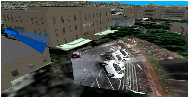
There are many cases where videos can have a geographic location. Some examples include traffic cameras, large-extent weather data, a webcam showing surf conditions, analytic GIS results through time, and feeds from airborne cameras. This type of content can be displayed, in its correct geographic context, as a video layer in ArcGlobe.
What are video layers?
Video layers are similar to highly temporal raster layers that display draped on the surface of ArcGlobe. They can be played, paused, rewound, and synchronized with other layers through the use of temporal layer settings.
Video layers display on the surface of ArcGlobe and will conform to the underlying elevation data. This means that their defined location must intersect the elevation surface, something particularly important when using a camera's metadata as the georeferencing source. Video feeds will not display on 3D objects, such as the sides of buildings.
Like other layer types, video layers are saved with the ArcGlobe document and have property pages for defining the layer name, visibility, layer transparency, and so on. Video layers also honor their position in the drawing order to allow easy integration with both regular GIS layers and other video feeds.

What constitutes a video layer in ArcGlobe?
Video layers consist of two components—an AGV file and the video data.
The AGV file contains the video georeferencing details and metadata on the video data, stored in XML format. Depending on the type of video source, the georeferencing information can be defined using either the camera's location/view direction or a rotated 2D bounding box. The required details for the video data will depend on how the video is being streamed but can be as simple as the location of an MPEG file. Different video sources will require different parameters defined in the AGV file.
Given that there are many potential sources of video data, the list of available sources of video feeds for ArcGlobe has been limited to three main options:
- An MPEG file
- A folder of frames (images)
- A custom DLL solution