The Create Airspace Areas tool allows you to associate vertical (flight level) information from airspace with two-dimensional features. Labeling these features with vertical information allows the display of three-dimensional information on a two-dimensional chart.
The tool uses settings, known as preferences, to refine its processing. Preferences include the following:
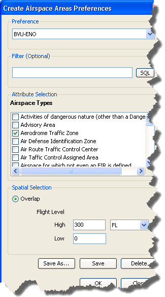
- Filter—An optional SQL where clause applied to Airspace features. Use this to limit processing to features specified in the where clause.
- Airspace Types—Limit processing to specific Airspace types.
- Spatial Selection—Limit processing to features that overlap and exist between specified high-low flight levels.
These settings apply to all sessions and tool executions. You can create and save multiple preferences. This allows you to share and reuse preferences throughout your enterprise.
- Start ArcMap.
- On the main menu, click Customize > Production > Production Properties.
The Production Properties dialog box appears.
- Click Aviation Properties in the list on the left side of the Production Properties dialog box.
- Ensure that the correct product library and production database are set.
- Click the cell next to Create Airspace Areas Preferences and click the ellipsis (...) that appears.
The Create Airspace Areas Preferences dialog box appears.
- Optionally, click SQL to build a WHERE CLAUSE to further define the features to process.
- In the Airspace Types list, check the check boxes next to the types you want to include in the processing.
- In the Spatial Selection area, type numeric values for High and Low flight levels.
- Click the drop-down arrow next to the High text box and choose a unit of measure.
- Click Save.
The Preference Name dialog box appears.
- Type a name for the preference.
- Click OK to close the Preference Name dialog box.
The preference name appears in the Preference drop-down list at the top of the Create Airspace Areas Preferences dialog box.

- Optionally, click Save As to save an existing preference with a new name.
- Optionally, click Delete to remove the preference.
- Click OK to close the Create Airspace Areas Preferences dialog box.