Obstruction identification surfaces (OIS) are imaginary surfaces that surround airfields and identify obstruction areas. They can be generated for both civilian and military purposes based on the FAA FAR Part 77 specification.
The heliports consist of the following surfaces:
- Primary surface—The area of the primary surface coincides in size and shape with the designated takeoff and landing area of a heliport. This surface is a horizontal plane at the elevation of the established heliport elevation.
- Approach surface—The approach surface begins at each end of the heliport primary surface with the same width as the primary surface, and extends outward and upward for a horizontal distance of 4,000 feet where its width is 500 feet. The slope of the approach surface is 8:1 for civilian heliports and 10:1 for military heliports.
- Transitional surface—These surfaces extend outward and upward from the lateral boundaries of the heliport primary surface and from the approach surfaces at a slope of 2:1 for a distance of 250 feet measured horizontally from the centerline of the primary and approach surfaces.
- Start ArcMap.
- Optionally open the map that contains the runways for which you want to generate OIS features.
- On the main menu, click Customize > Toolbars > Aviation Airports.
- Click the Obstruction Identification Surfaces button
 on the Aviation Airports toolbar to open the Obstruction Identification Surfaces window.
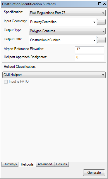
 - Click the Heliports tab.
- Click the Specification drop-down arrow and choose FAA Regulations Part 77.

- Define the input features.
The input features can be in a feature class or shapefile that contains points, lines, or polygons. The feature class or shapefile must be z enabled and have a vertical (z) coordinate system. The RWYDESG field name (alias = Runway Designator) must be populated in this format: 09/27
If the runway features have been loaded in the map
Click the Input Runway drop-down arrow and choose the feature class that contains the runway features for which to create OIS features.
If the runway features are not in the map
Browse to the layer that contains the runway features.
- Click the Output Type drop-down arrow and choose an output type for the OIS features.
- Polygon Shapefile—The OIS features are generated in a new or existing polygon shapefile. If an existing shapefile is selected, the features are appended to it. All the OIS features are written to a single shapefile.
- Multipatch Shapefile—The OIS features are generated in a new or existing multipatch shapefile. If an existing shapefile is selected, the features are appended to it. All the features are written to a single shapefile.
- TIN—The OIS features are generated in a new TIN. One TIN is created for each surface. If there are multiple runway features, one directory is created for each one.
- Polygon Features—The OIS features are appended to an existing polygon feature class. All the features for the runways are appended to the same feature class.
- Multipatch Features—The OIS features are generated in a new or existing multipatch feature class. All the features for the runways are appended to the same feature class.
- Choose the output path for the OIS features.
If the feature class or shapefile is loaded in the map
Click the Output Path drop-down arrow and choose the feature class or shapefile that will store the OIS features.
If the feature class or shapefile is not loaded in the map, or the output type is a TIN
Click the ellipsis button (...) next to the Output Path text box and browse to the feature class or workspace in which the shapefile or TIN will be created.
- Type a value that represents the highest point on the runway in the Airport Reference Elevation text box.
The tool will automatically populate this value from a z-value in your aviation database if you are using the AIS or Airports data model. Airport elevation is stored in the z-value of the ADHP point feature class in the AIS data model. In the Airports data model, elevation is stored in the z-value of the Airport Control Point feature class for records with the Point_Type field populated with AIRPORT_ELEVATION.
If the value is 0, the Obstruction Identification Surfaces tool automatically uses the highest z-value on the runway centerline endpoint to generate the OIS.
- Type a value that represents the direction of approach for the heliport in the Heliport Approach Designator text box.
This value is expressed in degrees. The valid range is 0 through 360.
- Click the Heliport Classification drop-down arrow and choose a classification for the heliport.
- CIVIL_HELIPORT—A heliport intended for civilian purposes.
- MILITARY_HELIPORT—A heliport intended for military purposes.
- Optionally check the Input is FATO check box.
This check box indicates whether the input features represent the final approach and takeoff (FATO) area. The default value is unchecked.
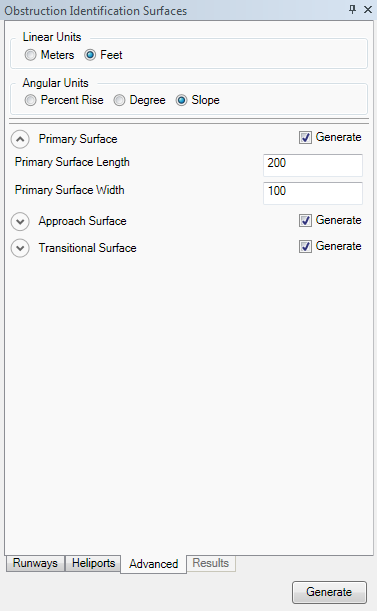
- If necessary, click the Advanced tab, click the arrow next to a group name, and modify any of the properties.
The properties are grouped based on the surface generated. There are default values for each parameter, but they can be modified.

- Optionally change the unit of measure for surface lengths and widths in the Linear Units area.
- Meters—Runway length is in meters.
- Feet—Runway length is in feet. This is the default.
- Optionally change the angular units for slope surfaces in the Angular Units area.
The default value varies based on the specification.
- Percent Rise—Slope angle is expressed as a grade (inclination) in percent.
- Degree—Slope angle is expressed in degrees.
- Slope—Slope angle is expressed as X units of run per 1 vertical unit.
- Optionally click the arrow next to Primary Surface to expand the group and change the values as necessary.
- Primary Surface Length—The primary surface length, excluding the length of the runway.
- Primary Surface Width—The primary surface width, excluding the length of the runway.
- Optionally click the arrow next to Approach Surface to expand the group and change the values as necessary.
- Approach Surface Extended Width—The width of the approach surface's outer edge.
- Approach First Section Length—The length of a surface that extends outward and upward from each end of the primary surface. The length of the first section of the approach surface.
- Approach First Section Slope—The slope of the first section of the approach surface. The default is 8 feet (8:1) for civilian heliports and 10 feet (10:1) for military heliports.
- Optionally click the arrow next to Transitional Surface to expand the group and change the values as necessary.
- Transitional Surface Slope—This is the slope of the transitional surface.
- Transitional Surface Width—This is the width of the transitional surface.
- If you do not want to generate a particular surface, uncheck the Generate check box for that surface.
- Click Generate at the bottom of the Obstruction Identification Surfaces window.
The Results tab appears on the Obstruction Identification Surfaces window and displays the progress of the OIS creation process. Once the process is finished, the OIS appears in the map.