ArcGIS Desktop

  • ArcGIS Pro
  • ArcMap

  • ArcGIS Pro
  • ArcMap
ArcGIS Desktop

ArcGIS Online

The mapping platform for your organization

ArcGIS Desktop

A complete professional GIS

ArcGIS Enterprise

GIS in your enterprise

ArcGIS for Developers

Tools to build location-aware apps

ArcGIS Solutions

Free template maps and apps for your industry

ArcGIS Marketplace

Get apps and data for your organization

  • ArcGIS Pro
  • ArcMap
Esri
English
  • English
  • Deutsch
  • Español
  • Français
  • 日本語
  • Русский
  • 简体中文
  • Sign In
user
  • My Profile
  • Sign Out

ArcMap

  • Home
  • Get Started
  • Map
  • Analyze
  • Manage Data
  • Tools
  • More...
  • More...
  • Extensions
  • Data Reviewer
  • Advanced data analysis
  • Assessing positional accuracy
  • Back to Top

Assessing positional accuracy

  • What is positional accuracy assessment?
  • Scenarios for using the PAAT
  • Fields associated with PAAT statistics
  • Starting a PAAT session
  • Adding points to layers during a PAAT session
  • Navigating the grid and features
  • Adjusting the map scale for the PAAT session
  • Toggling the auto-pick functionality
  • Enabling and disabling automatic feature or cell navigation
  • Viewing the PAAT session results
  • Changing the status or deleting a point
  • Disabling and enabling the three sigma threshold during a PAAT session
  • Changing the reporting units
  • Changing the confidence level
  • Changing the calculation method
  • Visiting an individual point
  • Ending a PAAT session
  • Clearing PAAT session results
  • Saving the session results

Sampling a database

  • Calculation methods for sampling
  • Sampling data
  • Updating sampling records

Checking valency on features

  • Scenarios for checking valency
  • Checking valency

Validating item metadata

  • Why validate item metadata?
  • Scenarios for validating metadata
  • Validating metadata using a schema
  • Validating metadata element content
  • Creating a custom check
  • Changing the calculation method

    This ArcGIS 10.3 documentation has been archived and is no longer updated. Content and links may be outdated. See the latest documentation.

    Available with Data Reviewer license.

    The statistical calculations during a Positional Accuracy Assessment session can be adjusted by changing the calculation method. You can choose to use either the National Geospatial-Intelligence Agency (NGA) standard or United States Geological Survey (USGS) standard. Each one calculates the values based on the specifications defined by those agencies.

    When the calculation method is changed, the statistics are automatically recalculated.

    1. Start a PAAT session.
    2. Click the Show Results button Show Results on the Positional Accuracy Assessment toolbar.

      The Positional Accuracy Session Results dialog box appears.
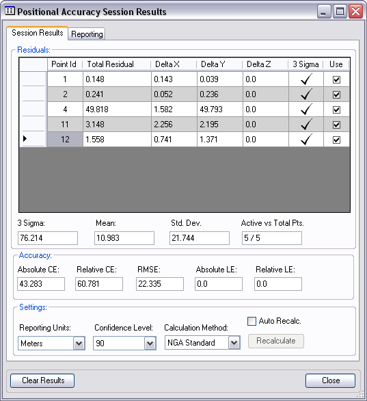
      Positional Accuracy Session Results dialog box
    3. In the Settings area of the Session Results tab, click the Calculation Method drop-down arrow to change the calculation method.

      The calculation method used to determine the change in statistics. Either the National Geospatial-Intelligence Agency (NGA) Standard or United States Geological Survey (USGS) Standard can be used. Each standard is based on a specification for the NGA and USGS, respectively.

      The statistics are recalculated using the method you choose.

    4. Click Close.

    Related topics

    • Changing the status or deleting a point
    • Disabling and enabling the three sigma threshold during a PAAT session
    • Changing the reporting units
    • Changing the confidence level

    ArcGIS Desktop

    • Home
    • ArcGIS Pro
    • ArcMap
    • Documentation
    • Support

    ArcGIS

    • ArcGIS Online
    • ArcGIS Desktop
    • ArcGIS Enterprise
    • ArcGIS Platform
    • ArcGIS Developer
    • ArcGIS Solutions
    • ArcGIS Marketplace

    About Esri

    • About Us
    • Careers
    • Esri Blog
    • User Conference
    • Developer Summit
    Esri
    Copyright © 2019 Esri. | Privacy | Legal