Available with Standard or Advanced license.
The Load A Topology To A Parcel Fabric geoprocessing tool loads a topology containing a parcel polygon feature class and a parcel line feature class. The topology must be validated against a required set of topology rules, and any topology errors need to be cleaned before the loading process. The following tools can be used to format parcel data and reduce topology errors prior to data loading.
Enforce coincidence between boundaries
Overlaps and gaps between adjacent parcel polygons will result in a large number of topology errors. Furthermore, if you maintain overlapping parcel polygons, such as subdivisions, tax parcels, and lots, you also need to ensure that overlapping polygon boundaries are coincident. Use the Integrate geoprocessing tool under System Toolboxes > Data Management Tools > Feature Class on the Catalog window to make overlapping polygon boundaries coincident it they fall within a specified tolerance. Using the Integrate tool minimizes the number of topology errors from the Must Be Covered By Boundary Of, Boundary Must Be Covered By and Must Not Intersect Or Touch Interior rules.
Create lines from polygons
To load parcel data to a parcel fabric, a clean topology of parcel polygons and parcel lines is required. If you do not maintain parcel lines, you can create lines from your polygons using the Polygon To Line geoprocessing tool under System Toolboxes > Data Management Tools > Features > Polygon To Line in the Catalog window. Make sure to choose Identify and store polygon neighboring information on the Polygon To Line dialog box to ensure that duplicate lines are not created for neighboring polygons sharing a common boundary. COGO dimensions are generated from the line shape geometry during the migration process.
Check and repair geometries
Check the geometries of the lines created from your polygons using the Check Geometry geoprocessing tool located under System Toolboxes > Data Management Tools > Features in the Catalog window. The tool generates a list of lines with bad geometries. Depending on the quality of your polygons, lines may be created that have errors, such as self-intersecting lines, null geometries, or duplicate vertices. Geometry errors should be repaired prior to loading. Run the Repair Geometry geoprocessing tool located under System Toolboxes > Data Management Tools > Features to repair bad line geometries.
It may be necessary to rebuild polygons from the lines after repairing bad line geometries to avoid topology errors between the polygons and lines in the data loading process. If you need to do this, use the Feature To Polygon geoprocessing tool located under System Toolboxes > Data Management Tools > Features to build polygons from lines. Attributes from the original polygons will need to be transferred to the newly built polygons.
Split polylines and check curves
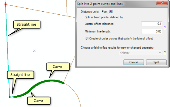
Parcel lines must be two-point lines or curves representing a single boundary. When lines are created from polygons, polylines are generated that contain segments representing straight lines and curves. For example, a curve could be made up of some densely or sparsely populated line segments. Use the Curves And Lines Add-In to identify and split curves and straight lines from polylines (multisegmented lines).

When generating curves, the add-in groups a series of segments into a single curve if the bend between each segment is less than the specified Lateral offset tolerance. Choose Create circular curves that satisfy the lateral offset to create a curved line from the series of segments. Segments are split into individual lines if the bend between line segments is greater than the lateral offset tolerance and segments are longer than the specified Minimum line length. You may need to adjust and test your tolerances until you identify tolerance values that work best for your data.
In some cases, a polyline represents a natural boundary such as a river. In these cases, you do not want to split the polyline up into individual segments prior to migration. These polylines can be migrated as natural boundaries or as line strings to the parcel fabric. You can control whether or not a polyline is migrated as a natural boundary by modifying the Minimum Line String Segment Count tolerance on the Load a Topology to a Parcel Fabric dialog box of the Load A Topology To A Parcel Fabric tool . For example, if you specify a tolerance of 20, polylines with more than 20 segments will be migrated as line strings. Polylines with less than 20 segments will be split into individual parcel lines.
Multipart to singlepart lines
The topology requires that line features must be single-part lines. Use the Multipart To Singlepart geoprocessing tool to separate (explode) multipart features into separate, single-part features. You can also use the Explode tool  located on the Advanced Editing toolbar to separate a selected multipart feature into its individual, component features in ArcMap.