Available with Standard or Advanced license.
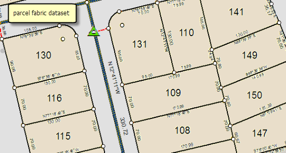
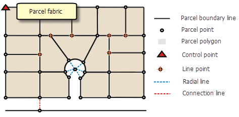
A parcel fabric stores a continuous surface of connected parcels or parcel network. Parcels are made up of polygon features, line features, and point features. Parcel polygons are defined by lines, which store COGO dimensions. COGO dimensions should ideally or eventually match recorded dimensions from the record of survey or plan. Each parcel has its own set of lines, which means there are two lines that define the common boundary between adjacent parcels.
Parcel lines have endpoints, which are common between adjacent parcels. Common points between parcels establish connectivity and maintain internal topological integrity in the network. Parcel points store x, y, z coordinates which locate the parcel on the ground. Line points are assigned to parcel points that lie on an adjacent parcel boundary but do not split the boundary. Line points constrain the parcel point to lie on its adjacent parcel line. Control points are assigned to parcel points when running a fabric adjustment. Control points constrain and pin down the parcel point in the adjustment.
Connection lines can be used to link isolated blocks of parcels to each other or link parcel corners to control points. Because each and every parcel is either linked or connected, a seamless network of connected parcel boundaries, or parcel fabric, is formed.

A parcel fabric is made up of these elements:
- Parcel lines, which have different categories and store COGO dimensions
- Parcel points, which store x,y,z coordinates that can be adjusted in a fabric adjustment
- Parcel polygons, which store area, parcel identification information, and are defined by parcel lines
- Line points, which constrain parcel points to lie on the boundaries of adjacent parcels
- Control points, which are used in a fabric adjustment and have accurate coordinates for a physical location
- Plans (table), which store information about the record of survey
- Parcel fabric jobs (table), which track edits to the parcel fabric
- Accuracies (table), which store weights that are used on parcels and lines a fabric adjustment
- Adjustment vectors (table), which store sets of displacement vectors from fabric adjustments

Create a parcel fabric
A parcel fabric dataset is created under a feature dataset and inherits the spatial reference of the feature dataset. To create a new parcel fabric, right-click a feature dataset in the Catalog window , point to New and click Parcel Fabric.
Learn more about creating and managing a parcel fabric dataset