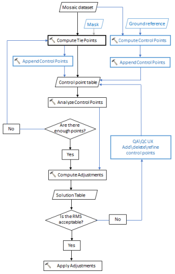
The goal of this workflow is to create a mosaic dataset where all images are accurately located. A mosaic dataset can be created with data from different sensors and different times. This can cause some misalignment of the images when your mosaic is created. The block adjustment tools can be used to accurately place your mosaic dataset and each item within it.
To adjust your mosaic dataset items, use the following steps:
- Compute tie points among the block of images.
- Optionally, compute control points between source images and a reference image.
- Combine the tie points and control points together.
- Optionally, analyze the control points.
- Compute the adjustments for sensor model/transformation for each image.
- Check the errors and recompute the adjustments, if necessary.
- Apply the adjustments to each image.

Creating tie points and control points
Tie points connect the same location on different images. These tie points match the images within the mosaic dataset together. Control points, on the other hand, match the items with locations on a reliable source dataset. With both types of points, the mosaic dataset will be accurate to both the source and also amongst the images within the mosaic. The tie points must be computed for the bundle block adjustment. The control points are optional, but a good idea to have to retain location accuracy between your mosaic dataset and the reference image.
- Use the Compute Tie Points tool to create a table with the tie points.
- Optionally, use the Compute Control Points tool to create a table with the control points.
- Use the Append Control Points tool to merge all the tie points and control points together.
- Use the Analyze Control Points tool to make sure that the control points are well distributed and have an acceptable error.
Adjusting the images
Now that you have your tie points and control points, you can calculate the adjustments needed for each image. The calculations take into account both types of points and adjust the images. Next you need to address the quality control of your solution adjustments. Remove any errors that do not reflect a good adjustment. Keep computing and editing the adjustments, and apply them when you are happy with the results.
- Use the Compute Block Adjustments tool to compute the necessary adjustments.
- Inspect the solution to ensure they accurately match the images. Delete any rows from the solution table that are inaccurate.
- Reiterate step 1 and step 2 until you are happy with the accuracy of the adjustments.
- Use the Apply Block Adjustment tool to persist the adjustments to the images within the mosaic dataset.