ArcGIS for Desktop

  • Documentation
  • Pricing
  • Support

  • My Profile
  • Help
  • Sign Out
ArcGIS for Desktop

ArcGIS Online

The mapping platform for your organization

ArcGIS for Desktop

A complete professional GIS

ArcGIS for Server

GIS in your enterprise

ArcGIS for Developers

Tools to build location-aware apps

ArcGIS Solutions

Free template maps and apps for your industry

ArcGIS Marketplace

Get apps and data for your organization

  • Documentation
  • Pricing
  • Support
Esri
  • Sign In
user
  • My Profile
  • Sign Out

Help

  • Home
  • Get Started
  • Map
  • Analyze
  • Manage Data
  • Tools
  • More...

Overview terrain

Available with 3D Analyst license.

The overview terrain is the coarsest representation of the terrain dataset and is intended for fast drawing at small scales. The overview is what's drawn by default when zoomed to the full extent of the terrain dataset. It is a vector-based thumbnail representation.

Point based data sources are always used in the overview terrain. Other Feature classes participating in the terrain can be represented in the overview by setting this property to TRUE in the creation process.

Only set those feature classes that must be represented in the overview to TRUE. For example, you probably don't need detailed breaklines, but you might need a clip polygon, particularly if the data boundary is irregularly shaped. If the boundary you have is detailed, generalize it and use the coarser representation for the overview. The detailed version should be used in more detailed pyramid levels.

The following image depicts an overview representation of the terrain dataset. The table of contents shown displays the current resolution this terrain is displayed at: Overview Terrain.
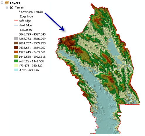
Example of a Terrain Overview

Related Topics

  • Building a terrain dataset using the New Terrain wizard
  • Building a terrain dataset with geoprocessing tools
Feedback on this topic?

ArcGIS for Desktop

  • Home
  • Documentation
  • Pricing
  • Support

ArcGIS Platform

  • ArcGIS Online
  • ArcGIS for Desktop
  • ArcGIS for Server
  • ArcGIS for Developers
  • ArcGIS Solutions
  • ArcGIS Marketplace

About Esri

  • About Us
  • Careers
  • Insiders Blog
  • User Conference
  • Developer Summit
Esri
© Copyright 2016 Environmental Systems Research Institute, Inc. | Privacy | Legal