ArcGIS for Desktop

  • Documentation
  • Pricing
  • Support

  • My Profile
  • Help
  • Sign Out
ArcGIS for Desktop

ArcGIS Online

The mapping platform for your organization

ArcGIS for Desktop

A complete professional GIS

ArcGIS for Server

GIS in your enterprise

ArcGIS for Developers

Tools to build location-aware apps

ArcGIS Solutions

Free template maps and apps for your industry

ArcGIS Marketplace

Get apps and data for your organization

  • Documentation
  • Pricing
  • Support
Esri
  • Sign In
user
  • My Profile
  • Sign Out

Help

  • Home
  • Get Started
  • Map
  • Analyze
  • Manage Data
  • Tools
  • More...

Moving the camera or view along a path

  1. Create the line feature or graphic you want to use as a path.
    Learn more about creating the line feature

  2. Click the Select Features button Select Features on the Tools toolbar and select the line feature or graphic you want to use as a path.

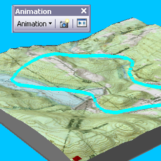
    A selected line feature to use as a path

  3. If the Animation toolbar is not present in your application, click View on the Main menu of the application, point to Toolbars, then click Animation.
  4. Click the Animation drop-down menu and click Create Flyby from Path.
  5. Optionally, check Apply in reverse order.

    The camera or view will begin at the other end of the path.

  6. Optionally, type a value in the Vertical offset text box (ArcScene and ArcGlobe only).

    An offset defines the height of the camera.

  7. Optionally, adjust the simplification factor.

    The simplification factor determines how much the path will be generalized for the animation.

  8. In ArcScene or ArcGlobe, choose a path destination option.

    Change the path destination option to determine how the observer and target are positioned during the animation.

  9. Optionally, uncheck Overwrite last imported track.

    Disabling this option will allow you to import additional tracks without overwriting existing ones.

  10. Click Import.
Tip:

When selecting Flyby mode as the path destination in ArcScene or ArcGlobe, click Orientation Settings on the Camera Flyby from Path dialog box to modify the way a camera's azimuth, inclination, and roll properties are calculated from the path.

Tip:

The properties of a keyframe can be edited using the Animation Manager.

Related Topics

  • About moving the camera or view along a path
  • Creating a path for use in animation
  • About playing an animation automatically or manually
Feedback on this topic?

ArcGIS for Desktop

  • Home
  • Documentation
  • Pricing
  • Support

ArcGIS Platform

  • ArcGIS Online
  • ArcGIS for Desktop
  • ArcGIS for Server
  • ArcGIS for Developers
  • ArcGIS Solutions
  • ArcGIS Marketplace

About Esri

  • About Us
  • Careers
  • Insiders Blog
  • User Conference
  • Developer Summit
Esri
© Copyright 2016 Environmental Systems Research Institute, Inc. | Privacy | Legal