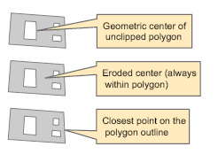
For labels that have a text symbol with a text background of type callout, you can use the Maplex Label Engine to set the anchor point for the callout symbol. The anchor point location options where the callout will snap to the feature are as follows:
- Geometric center (then closest point on outline)
- If the anchor point is unable to be placed at the geometric center of the polygon, it will be placed on the closest point on the outline to the label. The geometric center of the polygon is the center of gravity for the polygon. This center does not always fall within the feature; when it doesn't, the anchor point will be placed on the feature outline.
- Eroded center (always within polygon)
- The anchor point will be placed at the eroded center of the polygon. The eroded center is determined by peeling away the outer layers of the polygon like an onion until there is one center point left. This eroded center always falls within the polygon boundary.
- Closest point on the polygon outline
- The anchor point will be placed at the closest point on the polygon outline to the label.
- Geometric center of unclipped polygon (then eroded center)
- The anchor point will be placed at the geometric center of the unclipped polygon. If the polygon falls partly outside the current extent, the Maplex Label Engine will use the entire polygon to calculate the geometric center. If the anchor point cannot be placed at the geometric center due to a hole in the feature, the eroded center of the unclipped polygon will be used. Because the Maplex Label Engine is using the unclipped polygon to place the anchor point, it might be placed outside the current extent.
The default is Try geometric center followed by closest point on outline.

- Enable the Maplex Label Engine.
- Click the Label Manager button
 on the Labeling toolbar.
- Check the check box next to the layer you want to label.
- Choose a label class under the layer.
- Click the Properties button.
- Click the Label Position tab.
- Click the Anchor Points button.
- Choose a method to calculate the anchor point from the drop-down list.
- Click OK to close all dialog boxes.