Summary
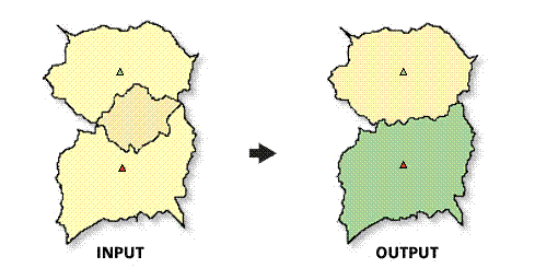
Removes overlap (cannibalization) between trade areas
Illustration

Usage
The spatial reference of the output feature class will be the same as the trade area layer.
The Trade Area Layer must be a polygon feature class.
In most cases, the Trade Area Layer will be a trade area created with Business Analyst.
The Remove Overlap Method parameter has two choices:
- THIESSEN_POLYGONS method will remove overlap using straight lines.
- The GRID method will remove overlap with a line that reflects the shape and curve of the input polygon feature class.
If trade areas do not overlap, the output feature class will contain the features from the input Trade Area Layer.
Syntax
RemoveTAOverlap_ba (InputFeatureLayer, AssociatedStoreID, {CenterOfTA}, ApproachToRemoveOverlap, OutputFeatureClass, {StoreLayer}, {StoreIDField}, {WayToDefineWeights}, {WeightField})| Parameter | Explanation | Data Type |
InputFeatureLayer | The input features containing the overlapping trade areas. | Feature Layer |
AssociatedStoreID | Unique ID field in the trade area layer. | Field |
CenterOfTA (Optional) | Field used to define the way a centroid is derived.
| String |
ApproachToRemoveOverlap | Defines the approach used to remove overlap between trade areas.
| String |
OutputFeatureClass | The feature class containing the new trade area features. | Feature Class |
StoreLayer (Optional) | The input features containing center points for the overlapping trade areas. In most cases, this will be a Business Analyst store layer. | Feature Layer |
StoreIDField (Optional) | Unique ID field in the store layer. | Field |
WayToDefineWeights (Optional) | Method for removing overlap when using the grid approach.
| String |
WeightField (Optional) | Field used to determine how the trade area overlap is influenced. Used when the grid approach and the weight definition method are set to USE_WEIGHT_FIELD. | Field |
Code Sample
RemoveTAOverlap Example (Stand-alone Script)
# Name: RemoveTAOverlap.py
# Description: Removes overlap between selected trade areas.
# Author: Esri

# Import system modules
import arcview
import arcpy

arcpy.AddToolbox("C:\Program Files (x86)\ArcGIS\Desktop10.3\Business Analyst\ArcToolbox\Toolboxes\Business Analyst Tools.tbx")

try:
# Acquire extension license
  arcpy.CheckOutExtension("Business")

# Define input and output parameters for the Remove Trade Area Overlap tool
  Path = "C:/temp/overlap.shp"
  IdFld = "<none>"
  OutPath = "C:/temp/RAPolygon.shp"

# Remove overlap based on trade areas
  arcpy.RemoveTAOverlap_ba(Path, IdFld, "USE_CENTROID", "THIESSEN_POLYGONS", OutPath)

# Release extension license
  arcpy.CheckInExtension("Business")

except:
  print arcpy.GetMessages(2)
Environments
This tool does not use any geoprocessing environments
Licensing Information
- ArcGIS for Desktop Basic: Requires Business Analyst
- ArcGIS for Desktop Standard: Requires Business Analyst
- ArcGIS for Desktop Advanced: Requires Business Analyst