ArcGIS for Desktop

  • Documentation
  • Pricing
  • Support

  • My Profile
  • Help
  • Sign Out
ArcGIS for Desktop

ArcGIS Online

The mapping platform for your organization

ArcGIS for Desktop

A complete professional GIS

ArcGIS for Server

GIS in your enterprise

ArcGIS for Developers

Tools to build location-aware apps

ArcGIS Solutions

Free template maps and apps for your industry

ArcGIS Marketplace

Get apps and data for your organization

  • Documentation
  • Pricing
  • Support
Esri
  • Sign In
user
  • My Profile
  • Sign Out

Help

  • Home
  • Get Started
  • Map
  • Analyze
  • Manage Data
  • Tools
  • More...

How Aggregate works

Available with Spatial Analyst license.

    The Aggregate tool resamples an input raster to a coarser resolution based on a specified aggregation strategy (Sum, Min, Max, Mean, or Median).

    Conceptually, the tool works as follows:

    1. It multiplies the cell resolution of the input raster by the factor specified by the cell factor parameter. The resulting value corresponds to the cell resolution of the output raster.
    2. It maps the spatial extent of the output cells onto the input raster.
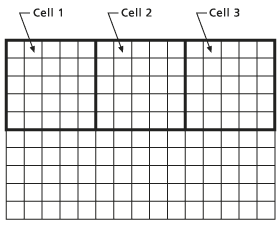
      Coarser output cells mapped onto input raster
      The coarser output cells mapped onto the input raster

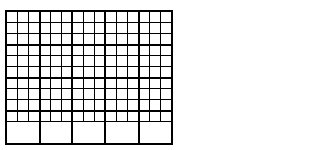
    3. It identifies the cells on which to perform the aggregation calculations. Cell locations from the input raster that fall within the extent of an output cell are included in the calculations for determining that cell's output value.
    4. It calculates the output value by determining the sum, minimum, maximum, mean, or median value of the cells from the input raster that fall within the output cell's spatial extent.
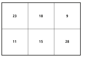
      Spatial extent of output cells mapped onto input raster
      The aggregation value is written to each cell on the output raster.

    Depending on the value specified for the cell factor (whether the division of the cell factor by the number of cells in a row or column leaves a remainder), the spatial extent of the input cells will not cover the same extent for the last cell in a row or column as the output raster. When this occurs, the value for the last output cell can be calculated with the available cells from the input raster that fall within the extent (Expand extent checked), or the raster can be truncated by removing the last cell from the output raster (Expand extent unchecked).
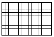
    The input raster
    The input raster

    Coarser output cells cover a larger extent than the input cells.
    The coarser output cells cover a larger extent than the input cells.

    Output with the Expand option
    Output with the Expand option set

    Output with the Truncate option
    Output with the Truncate option set

    Related Topics

    • An overview of the Generalization toolset
    • Aggregate
    • Altering the resolution of a raster
    Feedback on this topic?

    ArcGIS for Desktop

    • Home
    • Documentation
    • Pricing
    • Support

    ArcGIS Platform

    • ArcGIS Online
    • ArcGIS for Desktop
    • ArcGIS for Server
    • ArcGIS for Developers
    • ArcGIS Solutions
    • ArcGIS Marketplace

    About Esri

    • About Us
    • Careers
    • Insiders Blog
    • User Conference
    • Developer Summit
    Esri
    © Copyright 2016 Environmental Systems Research Institute, Inc. | Privacy | Legal