Summary
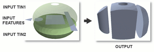
Creates 3D features by extruding each input feature between two triangulated irregular network (TIN) datasets.
Illustration

Usage
Only the portion of input features that overlap the XY extent of both TINs will be represented in the output.
The geometry of the extruded features depends on the geometry of the input features:
- Line and polygon input features result in the creation of multipatch geometry.
- Point input features result in the creation of line geometry.
Syntax
ExtrudeBetween_3d (in_tin1, in_tin2, in_feature_class, out_feature_class)
| Parameter | Explanation | Data Type |
in_tin1 | The first input TIN. | TIN Layer |
in_tin2 | The second input TIN. | TIN Layer |
in_feature_class | The features that will be extruded between the TINs. | Feature Layer |
out_feature_class | The output that will store the extruded features. | Feature Class |
Code sample
ExtrudeBetween example 1 (Python window)
The following sample demonstrates the use of this tool in the Python window.
import arcpy
from arcpy import env

arcpy.CheckOutExtension("3D")
env.workspace = "C:/data"
arcpy.ExtrudeBetween_3d("tin1", "tin2", "study_area.shp", "extrusion.shp")
ExtrudeBetween example 2 (stand-alone script)
The following sample demonstrates the use of this tool in a stand-alone Python script.
'''****************************************************************************
Name: ExtrudeBetween Example
Description: This script demonstrates how to use the
             ExtrudeBetween tool.
****************************************************************************'''

# Import system modules
import arcpy
from arcpy import env

arcpy.CheckOutExtension("3D")

# Set environment settings
env.workspace = "C:/data"

# Set Local Variables
inTIN1 = "ceiling"
inTIN2 = "floor"
inPoly = "study_area.shp"
# Ensure output has a unique name
outMP = arcpy.CreateUniqueName("extrusion.shp")

#Execute ExtrudeBetween
arcpy.ExtrudeBetween_3d(inTIN1, inTIN2, inPoly, outMP)
Environments
Licensing information
- ArcGIS for Desktop Basic: Requires 3D Analyst
- ArcGIS for Desktop Standard: Requires 3D Analyst
- ArcGIS for Desktop Advanced: Requires 3D Analyst