Summary
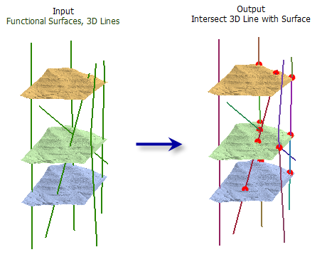
Computes the geometric intersection of 3D line features and one or more surfaces to return the intersection as segmented line features and points.
Illustration

Usage
Points (of intersection) and/or lines (resulting from input lines being broken at intersection points) can optionally be written to output feature classes.
All of the input line features will be in the output line feature class even if they do not intersect a surface.
The following fields are included in the output line feature class:
- OID_ORG—The OBJECTID from the original 3D line feature.
- SURF_FROM—The surface from which the 3D line segment began.
- SURF_TO—The surface from where the 3D line segment was drawn to.
The following fields are included in the optional output point feature class:
- OID_LINE—The OBJECTID from the original 3D line feature.
- SURFACE—The surface name where the intersecting point is generated from.
- DIST_ALONG—The distance from the beginning of the 3D line to the point of intersection.
Syntax
Intersect3DLineWithSurface_3d (in_line_features, in_surfaces, out_line_feature_class, {out_point_feature_class})| Parameter | Explanation | Data Type |
in_line_features | The input 3D line features. | Feature Layer |
in_surfaces | Specify one or more input raster or TIN surfaces to construct the geometric intersections. | Raster Layer; TIN Layer |
out_line_feature_class | The output line feature class that will contain a copy of the input lines split at the points of intersection. | Feature Class |
out_point_feature_class (Optional) | The optional point feature class that will contain the points of intersection. | Feature Class |
Code sample
Intersect3DLineWithSurface example 1 (Python window)
The following sample demonstrates the use of this tool in the Python window.
import arcpy
from arcpy import env

arcpy.CheckOutExtension('3D')
env.workspace = 'C:/data'
arcpy.Intersect3DLineWithSurface_3d('lines.shp', 'dtm_tin; elev.tif',
                                  'intersect_lines.shp', 'intersect_pts.shp')
Intersect3DLineWithSurface example 2 (stand-alone script)
The following sample demonstrates the use of this tool in a stand-alone Python script.
import arcpy
from arcpy import env

arcpy.CheckOutExtension('3D')
env.workspace = 'C:/data'
arcpy.Intersect3DLineWithSurface_3d('lines.shp', 'dtm_tin; elev.tif',
                                  'intersect_lines.shp', 'intersect_pts.shp')
Environments
Licensing information
- ArcGIS for Desktop Basic: Requires 3D Analyst
- ArcGIS for Desktop Standard: Requires 3D Analyst
- ArcGIS for Desktop Advanced: Requires 3D Analyst