Available with 3D Analyst license.
The Add Data Wizard is an optional tool that directs you to key decisions when adding data into ArcGlobe. The Add Data Wizard reduces the amount of time it takes to create a 3D view and provides instruction on which properties are important for different layer types. The pages that appear in the wizard vary with the type of data being added. Some data types, such as multiband raster images, have no pages at all.
The Add Data Wizard will be activated when data is added from either of these methods:
- Using the standard Add Data command

- Drag and drop between applications
- Drag and drop from the Catalog window
- A copy and paste layer action
Layers that already have their 3D properties defined, such as a 3D layer file or a layer copied from either ArcGlobe or ArcScene, will not trigger the Add Data Wizard. If you add multiple layers at once, the wizard will iterate through each layer.
For data types that have multiple pages in the wizard, you can click the Finish button and default properties will be used for the remaining configuration options. Clicking Finish on the first page without changing any properties will create the same layer as if the Add Data wizard were disabled.
Add Data Wizard Settings
When using the Add Data Wizard, the types of properties which you can set in advance encompass the following key areas:
- Consolidate into a single cache
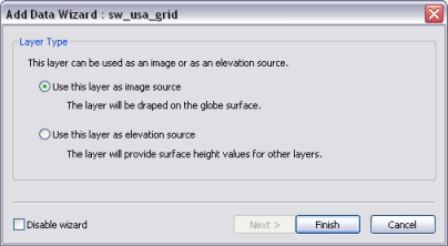
- Display as either elevation or draped image
- Display as raster or vector
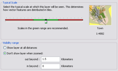
- Define the level of detail (LOD)
- Define distance visibility range
- Set real world symbol size
In the table below, you will see how the settings the Add Data Wizard offers correspond to particular data types. You can always change the properties after the layer is added by opening the Layer Properties dialog box.
| Data Type added | Wizard setting you will encounter | Additional comments |
|---|---|---|
Layer file created in ArcGlobe or ArcScene | The wizard will not be prompted | The 3D properties are already defined. |
Group layer | Consolidate into a single cache | Learn more about creating a group layer cache using the Add Data Wizard |
Single-band raster layer | Display as either elevation or draped image | |
Multiband raster layer | The wizard will not be prompted | The layer will be treated as an image by default. |
Point and Polyline vector layer (including shapefiles) | Multiple pages:
| Depending on whether you chose raster or vector from the first page on the wizard dictates if you will need to set all of the remainder pages. |
Polygon vector layer |
| |
Multipatch layer |
| |
Terrain dataset and TIN surface layer | The wizard will not be prompted | These layers are added as elevation layers by default. You can later change the display by dragging the layer in the table of contents into the Draped category. The layer will appear as a surface, useful for visualization and analysis. |
Annotation layer | Multiple pages:
|
The following images are example pages you will see in the Add Data Wizard depending on the data type. The first example is for a single-band raster layer; the second example is typical for vector layers to set level of detail and visibility distance ranges. If you don't accept the defaults, the settings require minimal interaction such as selecting an option, adjusting values, or moving a slider bar.

