ArcGIS Desktop

  • Documentation
  • Support

  • My Profile
  • Help
  • Sign Out
ArcGIS Desktop

ArcGIS Online

The mapping platform for your organization

ArcGIS Desktop

A complete professional GIS

ArcGIS Enterprise

GIS in your enterprise

ArcGIS for Developers

Tools to build location-aware apps

ArcGIS Solutions

Free template maps and apps for your industry

ArcGIS Marketplace

Get apps and data for your organization

  • Documentation
  • Support
Esri
  • Sign In
user
  • My Profile
  • Sign Out

ArcMap

  • Home
  • Get Started
  • Map
  • Analyze
  • Manage Data
  • Tools
  • Extensions

Using the Replace With Model tool for multipatches

Available with 3D Analyst license.

The Replace With Model tool is available in the 3D Editor menu on the 3D Editor toolbar and is applicable only to multipatch features. This command will replace the geometry of the selected feature or features with a 3D model file you have saved on disk. The 3D model types supported include SketchUp, COLLADA, OpenFlight, VRML, or 3D Studio Max.

To enable the command, you must have the following:

  • An active edit session
  • At least one multipatch feature layer in your document
  • Selected at least one multipatch feature

The image below using Replace With Model shows how to update buildings constructed from extruded blocks into complex, textured multipatches.
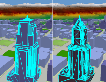
Use Replace with model to update buildings constructed from extruded blocks into complex, textured multipatches.

How to use the Replace With Model command:

  1. Click the Edit Placement tool Edit Placement on the 3D Editor toolbar.
  2. Select the multipatch feature or features that you want to edit.
  3. Hold the Shift key to select multiple features.
  4. Click the 3D Editor drop-down menu and click Replace With Model.
  5. Browse to the location of the 3D model on disk you want to use.
  6. Select the model file and click Open.

    The geometry of the selected feature is updated with the geometry of the 3D model.

Tip:
  • The use of relatively simplistic 3D models is recommended for display and analysis in ArcGIS. Note that 3D models with very large volumes of textures or highly complex geometries may not import or display in ArcGIS.

Related topics

  • Enabling 3D editing tools
  • Editing 3D multipatch features
  • Placing 3D models using the Insert tool
  • Moving a feature in 3D by interactively dragging it
  • Rotating a feature in 3D by interactively dragging it
  • Scaling a feature in 3D by interactively dragging it

ArcGIS Desktop

  • Home
  • Documentation
  • Support

ArcGIS Platform

  • ArcGIS Online
  • ArcGIS Desktop
  • ArcGIS Enterprise
  • ArcGIS for Developers
  • ArcGIS Solutions
  • ArcGIS Marketplace

About Esri

  • About Us
  • Careers
  • Insiders Blog
  • User Conference
  • Developer Summit
Esri
Tell us what you think.
Copyright © 2018 Esri. | Privacy | Legal