Available with 3D Analyst license.
Summary
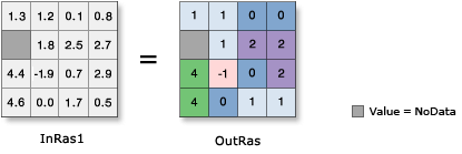
Converts each cell value of a raster to an integer by truncation.
Illustration

Usage
The input values can be either positive or negative.
If rounding is preferred to truncating, add a 0.5 input raster prior to performing the operation.
The maximum supported range of integer raster values is -2,147,483,648 (minimum size determined by -231) to 2,147,483,647 (maximum size determined by 231 – 1). If Int is used on a floating-point raster which has cells with values outside this range, those cells will be NoData in the output raster.
Storing categorical (discrete) data as an integer raster will use significantly less disk space than the same information stored as a floating-point raster. Whenever possible, it is recommended to convert floating-point rasters to integer with this tool.
Syntax
Int_3d (in_raster_or_constant, out_raster)
| Parameter | Explanation | Data Type |
in_raster_or_constant | The input raster to be converted to integer. In order to use a number as an input for this parameter, the cell size and extent must first be set in the environment. | Raster Layer; Constant |
out_raster | The output raster. The cell values are the input values converted to integers by truncation. | Raster Dataset |
Code sample
Int example 1 (Python window)
This example converts the input values to integer by truncation.
import arcpy
from arcpy import env
env.workspace = "C:/data"
arcpy.Int_3d("gwhead", "C:/output/outint")
Int example 2 (stand-alone script)
This example converts the input values to integer by truncation.
# Name: Int_3d_Ex_02.py
# Description: Converts each cell value of a raster to an integer by truncation
# Requirements: 3D Analyst Extension

# Import system modules
import arcpy
from arcpy import env

# Set environment settings
env.workspace = "C:/data"

# Set local variables
inRaster = "gwhead"

# Check out the ArcGIS 3D Analyst extension license
arcpy.CheckOutExtension("3D")

# Execute Int
arcpy.Int_3d(inRaster, "C:/output/outint")
Environments
Licensing information
- ArcGIS Desktop Basic: Requires 3D Analyst or Spatial Analyst
- ArcGIS Desktop Standard: Requires 3D Analyst or Spatial Analyst
- ArcGIS Desktop Advanced: Requires 3D Analyst or Spatial Analyst