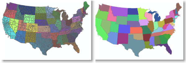
Often, you will want to merge adjacent polygons that share common values in your layer display—for example, you can create a map of states by dissolving county boundaries using their state name attribute field. 
Here are the steps for the simple example above:
- Open the Layer Properties dialog box and click the Symbology tab.
- Select Categories and click Unique values.
- In the Value Field drop-down menu, click the State Name field.
- Click the Add All Values button.
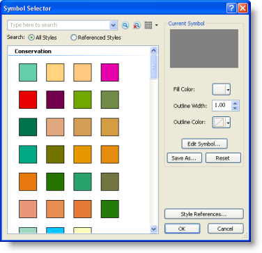
- Click the Symbol column heading and click Properties for All Symbols.
This displays the Symbol Selector dialog box in which you can set a number of symbol properties. In this case, you edit the symbols used for the layer.

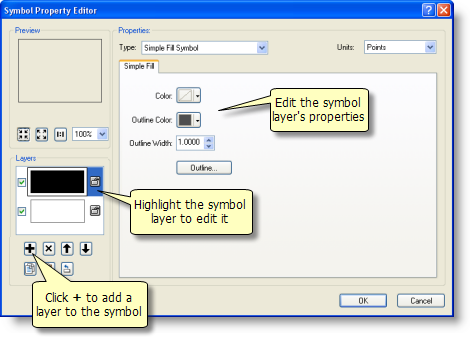
- Click the Edit Symbol button to open the Symbol Property Editor dialog box.

- Click the + button to add an empty symbol layer.
- Click the top symbol level and specify an outline width of zero.
- Click the small lock symbol next to the top symbol level to unlock this level.
- Click the bottom symbol level.
- Click the Color drop-down list and click No Color.
- Click the Outline Color drop-down list and select a color.
- Specify an Outline Width as you want it to appear on your map.
- Click the small lock symbol next to the bottom level to lock this level.
- Click OK to apply these symbol edits and to close the Symbol Property Editor dialog box.
- Click OK to close the Symbol Selector dialog box.
- Click the Color Ramp drop-down list and choose a color ramp.
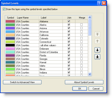
- Click the Advanced button and click Symbol Levels.
- Turn on Symbol Level Drawing by checking Draw this layer using the symbol levels specified below.
- Check Join on for all your symbols. Use CTRL and click the check boxes to turn Join or Merge on or off for all symbols in the list.
- Uncheck Merge for all your symbols.

- Click OK to accept changes and close the Symbol Levels dialog box.
- Click OK to accept changes and close the Layer Properties dialog box.