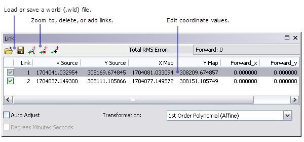
As you georeference a CAD dataset, you can manage the links and control points with the Link table. The link table displays the control points currently in memory. These can be the result of adding control points manually, or loading them from a world file.
To open the link table, click the View Link Table button  on the toolbar.

Edit control points
You can edit the x and y value of each control point by clicking the cell and typing the new value.
Highlight control points
Clicking an entire (Link) row highlights the control points in the map.
Load control points from a world file
To load control points from a world (.wld) file, click the Load Links button  and navigate to the file, then click Open. Loading a world file overwrites all control points currently in memory.
Insert or delete links
Clicking the Insert Link button adds an empty row to the table. Once the row is inserted, you can add control points to it by editing the individual cells and typing the values. A maximum of two links are possible with CAD datasets.
To delete a link, click the entire row and click the Delete Link button  or press the DELETE key.
Zoom to a link
To zoom to a link, click the entire row, then click the Zoom To Selected button  . Each successive click zooms in closer.
Create a world file
To save control points to a world file, click the Save Links button  . Name the file and click Save.