Available with Business Analyst license.
Overview
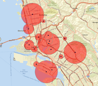
When generating Data-driven rings as trade areas, the size of the ring is determined by some numeric value in the store data, such as sales or store size (square feet). As an example for health care, it could be the number of hospital beds, while for media it might be signal strength of radio stations. The greater the data value, the larger the size of the ring. This analysis is primarily used to look at your competition, but it can also be used to analyze potential new locations.
A shopping mall with a Gross Leasable Area (GLA) of 1,000,000 square feet should be able to attract customers over a greater distance than one with a GLA of 250,000 square feet. Data-driven rings can give an analyst a rough idea of the drawing radius of shopping centers. The estimated population can determine whether the center's service area meets a certain threshold population required for a business. Other examples of data-driven rings include the following:
- The developer of small shopping centers uses rings based on gross leasable area (GLA) to analyze the effects of competing centers.
- Store managers can use rings driven by total sales to justify higher real estate costs in larger power centers.
Data-driven rings can be created around your stores when you specify a value in the store data. This value is set equal to a distance, and the rings are calculated in this way. This is typically used to create radius trade areas for competitors so a store owner can see if a store is being cannibalized. It can also be used to look for gaps in the market area.
Input Prerequisites
Store location(s) with at least one numeric attribute, which is used to define the size of the rings.
Example Output
Choose your stores' total sales field and specify $100,000, for example, to be proportional to a one-mile ring, then a store with $200,000 in sales will have a two-mile ring, a store with $750,000 will have a 7.5-mile ring, and so on.
To determine what value you want to use, choose the field that determines the size of the trade area. If you already know what value you want to use, type it in the text box. If you aren't sure what value you want to use, click Field statistic. The minimum, maximum, and mean values appear on the left side of the wizard.

Learn more about Data-driven rings