Available with Business Analyst license.
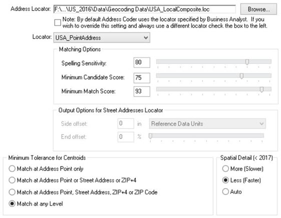
Using Address Coder you can use the Geocoding Options tab to indicate a locator's sensitivity and score options. The higher the value, the more restrictive matching becomes.

Output options for Street Addresses Locator
This section allows you to specify the precise location on the map where a feature will be drawn.
Side offset
Some address locator styles use reference data containing address range information for each side of the street. Address locators based on these styles can determine on which side of the street an address is located. For cartographic purposes, you can specify a side offset for geocoded features when using these styles of address locators. When you specify a side offset, the address locator locates geocoded features at the specified distance, based on map units, from the street centerline on the correct side of the street.
End offset
Address locators that use reference data with line geometry can interpolate a position along reference features for a geocoded address. To prevent features that are located at the end of a reference feature from falling on top of other features (for example, a cross street), the address locator can apply a squeeze factor, or end offset, to the location of a geocoded address. The end offset setting of an address locator can be expressed as a linear distance or a percentage of the length of the reference feature, between 0 and 50 percent. An end offset setting of 0 percent does not offset features from the end of the reference feature. An end offset of 50 percent locates all features at the middle of the reference feature. By default, the end offset setting for an address locator is 3 percent.
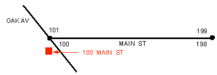
In the image below, the address, 100 MAIN ST, has been offset from the street feature by the side offset distance of 25 feet. This address falls at the end of the street feature and is, therefore, in line with the end of the street feature.

When streets intersect at odd angles, specifying an offset distance can have the undesirable effect of placing the address so it appears that the address does not belong to MAIN ST, but rather to OAK AV. This is shown in the image below.

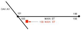
An end offset can be specified that adjusts the location of the address toward the center of the street feature. Using an end offset often rectifies the condition shown in the previous image. In this example, a squeeze factor of 10 percent was used to move the address toward the center of the street feature by a distance equal to 10 percent of the length of the street feature.

Minimum Tolerance for Centroids
This setting indicates the level at which you are willing to accept latitude-longitude coordinates. Regardless of the level you choose, you will always get the most accurate available.
Spatial Detail
When using the 2016 dataset (or older) the most detailed boundary come with a great deal of extra data that isn't needed for geocoding, using the More (Slower) option will add about 5 minutes processing regardless of the number of records in your file. The Less (Faster) option uses a slightly less accurate boundary but will do the spatial join 5 minutes quicker. Depending on where your addresses lie you may see a 3-4% difference in the geocodes that are applied. The Auto option will use the Less (Faster) option on files smaller than 5,000 records and the More (Slower) option on file with 5,000 or more records. Beginning with the 2017 dataset we plan on including a set of detailed boundaries without the non-essential geocoding data making this option unnecessary, hence, it will be disabled.