Available with Business Analyst license.
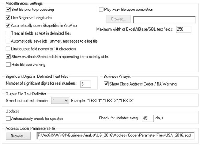
The Miscellaneous tab offers a variety of settings that will apply to each job processed.

- Sort file prior to processing—Sorting your file by ZIP Code or city and state greatly optimizes processing. A large, unsorted file can take longer to process than a sorted file. It is strongly recommended that you let Address Coder sort your file unless it is already sorted by either ZIP Code or city and state.
- Use Negative Longitudes—This will instruct Address Coder to output longitudes with a leading minus sign.
- Automatically open Shapefiles in ArcMap—If you have Esri's ArcMap installed, you can direct Address Coder to open the shapefile it created using ArcMap once processing is complete.
- Treat all fields as text in delimited files—It can be difficult to determine the data type of some fields in text files. If you are having trouble processing a delimited file, try checking this option.
- Show Available/Selected data appending items side by side— Shows all the data items you are licensed to append to your file. The left column shows the available items, and the right column shows the items you have selected.
- Hide file size warning— Indicates whether or not you want a warning message to appear when processing files that are over 1 GB in size. Access, dBASE, and shapefiles have a maximum physical size of 2 GB.
- Play .wav file upon completion—Specify any .wav file you want to make an audible sound upon completion.
- Maximum width of Excel/dBase/SQL text fields—For both Excel and dBASE, this option is usually needed only when you are processing a delimited or Excel file on input where the maximum field widths are unknown. When creating Excel and dBASE files, it can be helpful to place a maximum size on the width of a text field. In Excel this is more cosmetic; it will prevent all the columns from being extremely wide.
- Significant Digits in Delimited Text Files—This controls the number of digits shown after the decimal point. It defaults to six to show the proper precision for latitude and longitude.
- Output File Text Delimiter—You have a choice of three delimiters that can be used when creating delimited text files: single quote ('), double quote ("), or none.
- Updates—You can be reminded to check for updates and how frequently (in days).
- Address Coder Parameter File— The Address Coder Parameters File (.acpf) contains information required for Address Coder to run. This setting should have been set during installation. As Address Coder begins to process countries other than the US it is possible that you may have a number of .acpf files but for version 10.1 only the US is available.